- EF-1 tornadoes ripped through Cypress, Waller County areas with winds at more than 100 mph, NWS reports
- Houston-area storm damage updates: Clean up continues after NWS says two EF-1 tornadoes and powerful derecho ripped through SE Texas
- Low risk of damaging winds, hail from Saturday storms
- EF 1 tornadoes ripped through Cypress, Waller County areas at more than 100 mph, NWS reports
- Caddo Mounds State Historic Site to celebrate new visitor center, traditional grass house after 2019 tornado
Parts of central NC under flash flood risk today; Elsa becomes hurricane
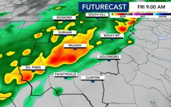
Raleigh, N.C. — The first round of storms started Thursday night, and we’re going to stay rainy for most of the day on Friday.
Friday morning will begin with a soggy drive to work for most in the WRAL viewing area.
“The rain’s already affecting folks in the Triangle area and northward and westward,” WRAL meteorologist Elizabeth Gardner said around 6:30 a.m. “If you’re east of the Triangle, you’re going to get your turn as well by the time we get to the end of the morning commute.”
Showers are moving a bit slower than previously thought on Thursday. We’ll still see scattered-to-widespread rain through the morning and afternoon.
Heavy rain is likely to begin impacting the Triangle between 7 and 8 a.m. The precipitation will taper off later in the evening with highs in the mid-to-upper 70s. Areas south and east will see temps in the 80s where there is a Level 1 severe weather risk.

The biggest concern with Friday’s storms will be flooding – with the eastern half of the WRAL viewing area under a medium risk for flooding.

“The problem is, there’s really not a great time to avoid the rain. If you leave early in the day, you’re going to run into rain [in the Triangle] and if you leave later in the day, you’ll probably run into rain at the coast,” said Campbell.
The rain will gradually abate by the end of the day on Friday, moving out of the Triangle by the evening commute and counties to the east as the evening wears on.

“Once we get to the afternoon, we start to see some of the rain taper off,” said Campbell. “We do improve as we head into Friday night.”
Before it ends, this system could bring an estimated 1 to 3 inches of rain, and Wake and counties to the east are under a medium risk for flash flooding through Friday.

“Friday will be the wettest day of the week as a cold front moves through NC but the weekend is trending drier,” Campbell said.
The rain will limit highs on Friday, with temperatures only reaching the upper 70s and low 80s.
4th of July planning
There may be a few sprinkles on Saturday morning, but not enough to ruin your holiday plans. But on Sunday, expect dry weather with lower humidity and temps in the mid-80s.
“If you’re headed to the beach this weekend – you’re in luck – the weather looks fabulous,” said Campbell.
Those at the beach on Thursday, Friday or Saturday, be aware there is a moderate rip current risk.

If you’re heading to the coast for the holiday weekend you should see some nice weather after storms move through on Friday. Rain chances are high on Friday, but low on Saturday and nonexistent on Sunday and Monday, so make be sure to pack the sunblock.
By 9 p.m. on Sunday, it will be 73 degrees — a bit cooler than normal for this time of year.
Elsa becomes hurricane, moving fast
Two new weather systems have developed out to sea and are projected to head toward the United States. This is the earliest date to see a fifth named storm during hurricane season.
Elsa reached hurricane strength on Friday morning and will bring heavy rain across the Windward and southern Leeward Islands.
As of 8 a.m. Friday, Elsa is around 175 miles east of Barbados with sustained winds up to 74 MPH and gaining strength. The National Hurricane Center says Elsa is moving west/northwest at 28 MPH. Elsa will impact the Lesser Antilles over the next 24 hours and then head towards Florida early next week.
Elsa’s track shifted slightly east on Thursday night as it recurves toward Florida. It includes southern Georgia going out to 8 p.m. on Tuesday.

The storm is likely to weaken a bit as it passes over the Caribbean and re-gains strength as it moves closer to Florida.
It will likely remain a tropical storm for the next five days, according to Gardner. Its possible that North Carolina could get remnant rainfall from the storm in the middle of next week.
Campbell says these systems are still days away from potentially making an impact on the U.S., but that if you’re planning any July 4 trips to the tropics, it’s something that may impact your travel.
“The big question is which islands Elsa interacts with this weekend,” said Campbell. “The mountainous terrain could have a big impact on it. The latest American model still brings remnant rain here early Thursday.”