- Mosquito activity on the rise due to rainfall, flooding across Texas
- Volunteers help Conroe community clean up in wake of flooding in Montgomery County
- Why leaders are urging NC residents to start hurricane prep now
- Storms could produce hail, damaging winds south of Charlotte
- Large hail and strong winds cause damage in San Marcos and the Hill Country
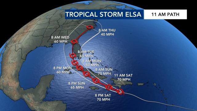
Latest forecast track shows almost all of North Carolina in Tropical Storm Elsa's path

Nearly all North Carolina is included in the path of Elsa, which dropped back down to tropical storm strength on Saturday morning.
The 5 p.m. update from the National Hurricane Center showed the center of the storm was close to the southwesten peninsula of Haiti.
Tropical storm watches are currently in place for Cuba and the Floriday Keys.
“It’s moving north and west,” said WRAL meteorologist Peta Sheerwood. “There’s quick movement with the storm.”
Top winds for the storm are currently at 70 miles per hour. Tropical Storm Warnings are in effect for Jamaica and Cuba.
The storm, which is moving 28 miles per hour in the west/northwest direction, is currently heading toward Hispaniola and Cuba. The system is more disorganized compared to Friday.
“The reason why it’s moving so quickly is because of some stronger upper level-winds,” Sheerwood said. “But it’s also making the top of the storm become a little bit more disorganized.”
The latest forecast track from the NHC showed Hurricane Elsa continuing to move west-northwest and interacting with Cuba, before eventually making its way into the southeastern Gulf before making a turn.
On Friday, Elsa became the first named hurricane of the season.
“The storm has weakened slightly – with the forward motion – it’s going to have a hard time maintaining its integrity,” said WRAL meteorologist Mike Maze.
“If it does weaken a little bit more, this could influence the track as we head into Sunday and Monday,” Sheerwood said. “But if it stays over warmer sea surface temperatures, just south of Cuba, we could see this strengthen and the track could continue to change.”
If the storm does make its way to the state, it looks like the storm would be here on Thursday, according to Maze. The path is subject to change in the coming days so we’re keeping a close watch on it. As of Saturday morning, Elsa was on track to go through North Carolina on Thursday.
There are two things to watch with the storm:
“Upper-level wind shear is going to increase over the next 24-48 hours, which should weaken the storm, in theory. Also, with interaction of the land-mass [around Cuba] may further weaken it, so by the time it does get into the Gulf, it may be much weaker than it’s forecasted now,” explained Maze.
Maze added that the spaghetti model plots are now showing a more general consensus that the storm will head in the current forecasted direction.

