- North Carolina behind on hurricane preparedness, study shows
- North Carolina way behind on hurricane preparedness, study shows
- New hurricane preparedness report doesn't rank North Carolina well
- New hurricane preparedness report doesn't rank North Carolina well
- Southport hosts annual Hurricane Expo ahead of the 2024 season
Elsa's track shifts to west, meaning more rain, tornado threat in forecast for the Triangle
There is a slight chance for showers in the forecast for Monday night, but the main event this week – the remnants of Tropical Storm Elsa – is likely to bring rain and wind to the Triangle on Thursday.
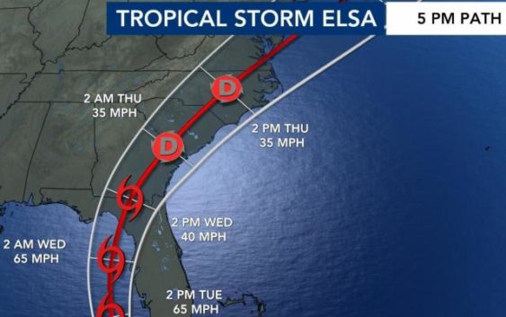
On Monday at 5 p.m., the latest update from the National Hurricane Center showed the storm had sustained winds of around 50 mph. It was headed northwest at 14 mph on a path over Cuba and into the eastern part of the Gulf of Mexico.
Elsa weakened as it moved over Cuba, but the hurricane center is expecting it to intensify again over open water in the Gulf of Mexico.
Many of the computer models have the system making landfall again in the “big bend” area of Florida on Wednesday morning and then going into Georgia, South Carolina and North Carolina.
The WRAL Severe Weather team is watching closely to determine the storm’s trajectory. Each forecast path update brings more clarity on the timing and impact of the storm in North Carolina.
The forecast cone shows the storm could cross North Carolina anywhere from the Triad to the coast. Expect any rain to begin late Wednesday and last into Thursday afternoon.
“The track of Elsa is farther west now, with the center of the tropical depression moving over us on Thursday,” said WRAL meteorologist Mike Maze after the 5 p.m. update. “On this track we have a greater risk for isolated tornadoes and rainfall.”
Tropical Storm watches and warnings were issued along Florida’s west coast Monday.
The storm would likely move away from the state by Thursday night.
There are two things to watch with the storm:
“Upper-level wind shear is going to increase over the next 24 to 48 hours, which should weaken the storm, in theory. Also, with interaction of the land-mass [around Cuba] may further weaken it, so by the time it does get into the Gulf, it may be much weaker than it’s forecasted now,” explained Maze.
Maze added that the spaghetti model plots are now showing a more general consensus that the storm will head in the current forecasted direction.