- Southport hosts annual Hurricane Expo ahead of the 2024 season
- How to protect your car before a hailstorm
- ‘We lost everything’: East Texas residents confront their future after flooding
- Here's how to get your flooding debris picked up by the City of Houston
- Mosquito activity on the rise due to rainfall, flooding across Texas
10 pm: Hurricane Elsa to make landfall early Wednesday morning
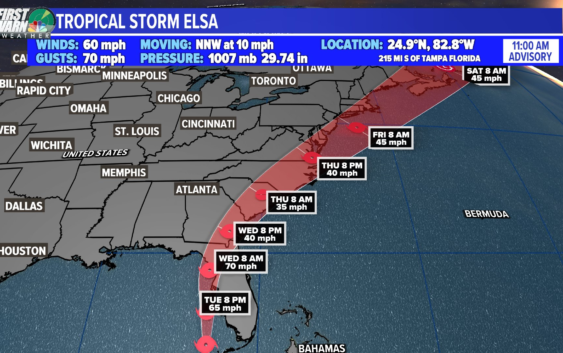
NEW ORLEANS — Hurricane Elsa is just to the west of Sarasota, FL on the W coast heading N at 14 mph, having picked up some forward speed since earlier this afternoon. The storm became a bit more organized this evening, although satellite imagery shows the strongest storms have collapsed. Dry air and wind shear have made it difficult for Elsa to rapidly intensify. Landfall is now expected to be as a tropical storm.
Landfall is expected north of Tampa early Wednesday. Models are in good agreement with this general track, eventually moving off the East coast, still as a tropical storm.
We’re not expecting any impacts along our part of the Gulf Coast.
2021 Hurricane Season Outlook
The 2021 Atlantic Hurricane Season is forecast to produce more storms than average. The reason for this is the lack of El Nino, which typically features more wind shear. We also expect warmer than average sea temperatures and an active West African Monsoon.
After a record-breaking 2020 hurricane season, we now know the Greek alphabet will no longer be used to name storms.
The World Meteorological Organization announced the Greek alphabet will not be used in the future because it “creates a distraction from the communication of hazard and storm warnings and is potentially confusing.”
There has been only one other season that used the extra set of names, and that was in 2005. The World Meteorological Organization released a new set of supplemental names that will be used if the season exhausts the standard list.
► Track the tropics with live updates delivered directly to your phone. Text APP to 504-529-4444 to download the FREE WWL-TV News app now or find us in the iOS App Store or Google Play.