- Two Fayetteville homes damaged in fire near Ramsey Street
- Two Fayetteville homes damaged in fire
- Roof torn from FedEx Ship Center in Michigan following multiple confirmed tornadoes
- Highway 90 reopening over Trinity River after being shut down for flooding
- Highway 90 reopens over Trinity River after being shut down for flooding
Wildfire haze decreases on Friday; Triangle moves to Code Yellow
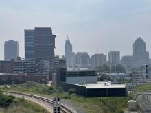
We’ve spent the last couple of days draped in smoke from wildfires from the western part of the United States and even Canada. The haze traveled all the way across the country into North Carolina.
The smoke prompted a Code Orange alert for air quality over nearly all of the state on Thursday, which expired at midnight. Air quality will improve slowly each day through the weekend with a moderate (Code Yellow) air quality forecast for Friday and Saturday, with things returning close to normal by Sunday.
The moon did appear orange on Friday morning because of the lingering haze. Upper level winds will steer most of that smoke a bit more back to our west.
“We see that pretty regularly during the summer,” said WRAL meteorologist Elizabeth Gardner of the Code Yellow. “It’s nothing to really be too concerned about.”

As for the temperatures, expect more heat, but nothing too unseasonably warm. WRAL meteorologist Kat Campbell says we have a 30% chance at seeing showers Friday.
Highs are in the upper 80s for much of the area and most folks will stay dry.

“A few afternoon thunderstorms are possible tomorrow with highs in the upper 80s,” Campbell said. “The weekend is seasonal with highs in the upper 80s to low 90s and partly cloudy skies. There is a slim chance of a thunderstorm Saturday,” she added.

Campbell also noted that Friday marks the return of a full moon and it should come with good visibility.
“[Friday] is the full buck moon,” Campbell said. “There should be good viewing along with a few planets visible.”
