- Austin could see heavy rains, possible flooding over the next few days
- Families of campers, counselors who died in Texas Hill County floods sue Camp Mystic
- Small plane bound for Jamaica with hurricane relief supplies crashes in Florida neighborhood
- Ask the Meteorologist: Did a tornado hit Johnston County Saturday night?
- Demolition begins on flood-damaged homes in Stoney Creek as neighbors await relief
Heavy rain prompts flood advisory for the San Antonio area
Showers and thunderstorms in the San Antonio area on Monday means that drivers’ commute may be impacted, especially if there is flooding.
The National Weather Service is sending frequent updates on its social media pages as showers and thunderstorms make their way through San Antonio, the Hill Country, and surrounding areas.
As of 7:30 a.m., heavy rain, accompanied by wind gusts up to 50 mph, was headed into western Bexar County and portions of San Antonio. A longer commute is likely in the San Antonio area due to weather conditions.
A flood advisory was issued for Bexar, Wilson, and southwest Guadalupe counties Monday morning as rainfall lingered in the Southern San Antonio area. Meanwhile, a flash flood warning for areas in northwest Bexar County such as Boerne, Helotes, and Fair Oaks Ranch was extended to 12:15 p.m. Moderate to heavy rainfall was ongoing on parts of the I-35 corridor throughout the morning. Local drivers should be advised of possible flooding during their commute and aware of areas prone to flooding.
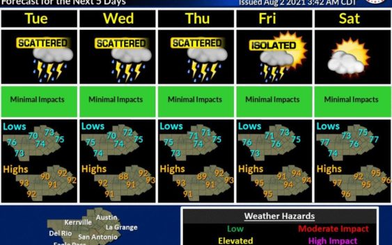
The National Weather Service is warning residents in and around San Antonio of possible flooding as showers and thunderstorms are likely most of this week.
National Weather ServiceAs always, the National Weather Service is reminding drivers to “turn around, don’t drown.”
The latest forecast indicates that chances of scattered showers and thunderstorms will continue through the middle of the week, but is expected to decrease by the weekend.
Read more from Sarah