- Early voting for May 28 primary runoff elections will go on, despite storm damage
- Hurricane survival kit: How to keep your family safe when a hurricane hits
- Houston-area storm damage: Update on status of schools, power outages and resources for storm victims
- EF-1 tornadoes ripped through Cypress, Waller County areas with winds at more than 100 mph, NWS reports
- Houston-area storm damage updates: Clean up continues after NWS says two EF-1 tornadoes and powerful derecho ripped through SE Texas
Tracking the tropics: Tropical Storm Fred could form today or tomorrow
We’re monitoring a ‘Potential Tropical Cyclone’ that is a disturbance that is not yet a tropical cyclone but expected to be soon.
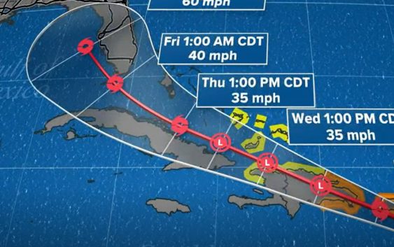
HOUSTON — The KHOU 11 weather team and National Hurricane Center are keeping a very close eye on Potential Tropical Cyclone 6.
What is a ‘potential tropical cyclone?’ It’s a disturbance that’s expected to become a tropical cyclone.
The good news is, for Texas, this disturbance is expected to stay well to our east and will not have impacts on the Houston area.
Potential Tropical Cyclone 6 is expected to become a tropical storm as it moves through the Lesser Antilles. The next name on the list is ‘Fred.’ That could happen sometime Tuesday or Wednesday. Tropical storm conditions are possible in portions of the Virgin Islands and Puerto Rico beginning tomorrow, then in the Dominican Republic by Wednesday. Florida and the Bahamas will want to watch this closely.
We’re keeping a close eye on it as it moves through the Caribbean.
Below you will find the latest position and forecast path
Tropical tracker interactive map
It’s been very quiet in the tropics
It has been 31 days since a named storm (Elsa) existed in the Atlantic basin.
The last advisory issued from the National Hurricane Center came on July 9. Since then the basin has remained very quiet all while the Eastern Pacific experienced an uptick in activity. Typically, a rule of thumb is that when the Pacific is active, the Atlantic is not and vice versa.
Well, the atmosphere has large-scale circulations, areas of rising motion and areas of sinking motion. The active locations, in this case, the Pacific, are active because of large-scale rising motion helping to facilitate storm development. That rising motion is balanced by sinking motion, which is occurring in the Atlantic and other areas of the Pacific. Large-scale sinking hasn’t been the only issue with getting the Atlantic to wake up, Saharan dust plumes have kept the middle and upper levels of the atmosphere dry as a bone. Tropical systems need a moist, humid environment and that wasn’t found in the Atlantic the past month.
Fast forward to now, what’s changed?
For one, the calendar. Climatology favors an increase in Atlantic tropical activity as we enter the middle of August as the oceans near their peak in terms of temperatures and all other ingredients become primed this time of the year. The Saharan dust, though, is still very much present has retreated a bit farther north allowing for some thunderstorms to cluster and try to begin and organize.
RELATED: What is Saharan dust?
What’s an “Invest?”
Invest is short for “investigative area,” the number cycles from 90 to 99 and then repeats, just to keep track of them. The “L” at the end signals that the investigative areas we are referencing are in the Atlantic. If it was a system in the eastern Pacific the letter would change to an ‘E’ and so on for other basins.
Overall, the environmental conditions are far from ideal to be conducive for any sort of large-scale development. In fact, the two areas are struggling against numerous factors. For one, the dry, Saharan air to the north may get pulled into their circulations. That would choke off the storm and stall any development potential. Upper-level winds, although not terribly strong, are enough to force a young, disorganized system to wobble and become tilted. Hurricanes and tropical storms are vertical heat engines. When they become tilted, they are no longer effectively pulling energy from the ocean and dispersing it to developing convection.