- WATCH: Video Shows Confirmed Tornado touches down in Columbus County
- Residents begin clean up after storms, apparent tornado roll through NC Tuesday
- NC State researchers find increased fecal contamination in coastal waters due to sunny day flooding
- Flooding lingers in Liberty County neighborhoods near Trinity River with more rainfall expected
- North Carolina behind on hurricane preparedness, study shows
Here's how Tropical Storm Fred will impact the Carolinas
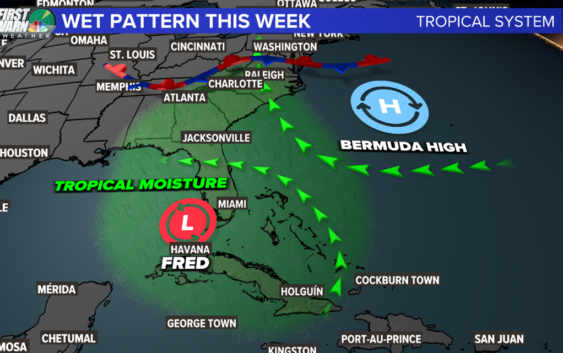
No matter what Fred does, we are going to see rain this week.
CHARLOTTE, N.C. — Wet weather is forecast for the Carolinas this week with additional rainfall possible from Fred across the Southeast.
As of Sunday morning, Fred is has regained tropical storm status as the disturbance moves north-northwest in the southeastern Gulf of Mexico. Maximum sustained wind remains at 40 mph with wind gusts up to 50 mph.
Some additional strengthening is possible as Fred moves through the Gulf. By late Monday or early Tuesday, landfall is forecast along the northern Gulf coast. It’ll be most likely the western Florida panhandle or Alabama.
Starting Sunday, a very rainy pattern will begin developing in the western Carolinas. Most of this initial rain will not be directly associated with Fred but rather from the broader weather pattern that is steering the storm.
This stalled front brings rain to the Carolinas Sunday even before any of the uncertainty around Fred arrives. If Fred survives beyond landfall, then its moisture would add to rainfall totals Tuesday through Thursday.
Heavy rain will allow for localized flooding due to saturated grounds from Saturday’s storm and additional rainfall this week. By the end of the week, 4 – 8 inches of rain are possible for the mountains and the foothills. 2 – 4 inches are possible for portions of the Piedmont and Metro Charlotte. Most of the South Carolina Piedmont and the Sandhills will see closer to 1 – 2 inches.
The further east the storm travels, the more rain North Carolina and South Carolina will experience. The further west the storms travels, the less rain the Carolinas will experience.
Tropical moisture associated with Fred, regardless of Fred’s strength, could cause a risk of flash flooding, especially in low-lying areas and portions of the western North Carolina foothills and mountains, where a risk of mudslides exists.
The National Hurricane Center, the branch of the National Weather Service which forecasts tropical weather, is responsible for issuing the official forecast cone for Fred. The forecast cone is eligible for updates four times a day: 5 a.m., 11 a.m., 5 p.m., and 11 p.m.
Elsewhere in the tropics, Tropical Storm Grace formed yesterday and has weakened slightly as it moves over the eastern Caribbean Islands. The disorganized system has maximum sustained wind of 40 mph.
A Tropical Storm Warning is in place for Puerto Rico and the U.S. Virgin Islands. The latest track from the NHC has Grace near or offshore the southwest Florida coast by mid-late week. There’s still a lot of time to watch this system.
The National Hurricane Center is monitoring a small area of low pressure about 200 miles north-northeast of Bermuda. Some development is possible over the next couple of days as the system drifts slowly southward.
However, by Tuesday, environmental conditions are expected to become hostile for formation. It has a low chance (30%) over the next five days.