- Southport hosts annual Hurricane Expo ahead of the 2024 season
- How to protect your car before a hailstorm
- ‘We lost everything’: East Texas residents confront their future after flooding
- Here's how to get your flooding debris picked up by the City of Houston
- Mosquito activity on the rise due to rainfall, flooding across Texas
Fred weakens after landfall, but still set to bring heavy rain, isolated tornadoes to parts of NC
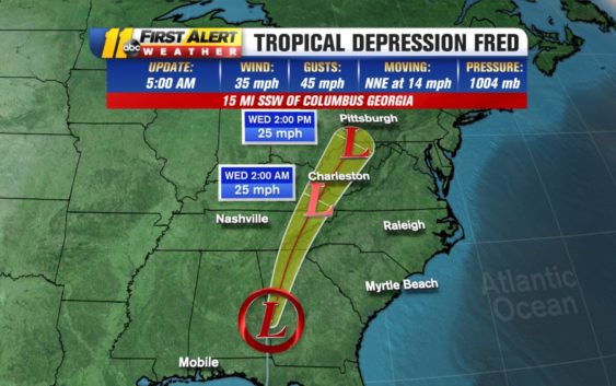
RALEIGH, N.C. (WTVD) — Fred made landfall on the Florida Panhandle on Monday afternoon; now it is pushing through Georgia and into the North Carolina mountains.
Fred has picked up some speed and will push through North Carolina today and tomorrow.
According to the National Hurricane Center, Fred weakened to a tropical depression with 35 mile per hour maximum sustained winds, and it was moving at about 14 miles per hour.
5am 8/17: Fred is now a tropical depression. It will move across the southern Appalachians tonight, and into the central Appalachians by early Wednesday. Fred is expected to degenerate into a remnant low by tonight and merge with a frontal system on Wednesday. @ABC11_WTVD pic.twitter.com/IkZOyOmDdg
— Kweilyn Murphy WTVD (@KweilynM) August 17, 2021
Despite weakening, Fred is still dumping a large amount of rain along its path and it could spawn some tornadoes in its outer bands. The farther east you go, the lower the risk for heavy rain and isolated tornadoes.
The first bands could arrive late morning Tuesday. A larger group of storms could move in during the afternoon, overnight and into Wednesday morning.
Most of central North Carolina will get less than an inch of rain. However, it’s not impossible that certain areas will record more than an inch due to a strong popup storm in the area.
No deaths have been reported from Fred, though thousands of Florida Panhandle residents were reported without power in the hours after its late Monday landfall. Emergency crews in the Panhandle were repairing downed power lines and clearing toppled trees in Fred’s aftermath.
Grace
Grace lashed earthquake-damaged Haiti as a tropical depression on Monday, dumping up to 10 inches of rain before regaining tropical storm status early Tuesday. The heavy rains pelted people huddling in fields and searching for survivors.
The storm couldn’t have come at a worse time for Haitians struggling to deal with the effects of Saturday’s 7.2 magnitude earthquake, blamed for more than an estimated 1,300 deaths.
Forecasters said Grace was moving early Tuesday near or over the Tiburon Peninsula of Haiti on a forecast track expected to take it between southeastern Cuba and Jamaica by Tuesday afternoon. It had top sustained winds of 40 mph and was headed to the west near 16 mph.
The Miami-based hurricane center said Grace could be near hurricane strength when it approaches Mexico’s Yucatan peninsula late Wednesday or early Thursday.
Henri
Tropical Storm Henri, meanwhile, formed Monday southeast of Bermuda and by early Tuesday was about 135 miles south-southeast of that island, where a tropical storm watch was in effect. The small tropical cyclone had 50 mph winds and was moving south-southwest at 5 mph.
Henri was expected to pass well south of Bermuda later Tuesday or Tuesday night, the hurricane center said.
Copyright © 2021 WTVD-TV. All Rights Reserved.