- Rock Hill storm damage costs are 'somewhere around $5 million.' That number doesn't include damage to personal property
- Rock Hill storm damage costs are 'somewhere around $5 million.' That number doesn't include damage to personal property
- ‘Somewhere around $5 million’ | Rock Hill officials see major storm damage costs
- The deadliest tornadoes to ever hit Austin
- Whiteville resident recalls events from Tuesday nights tornado
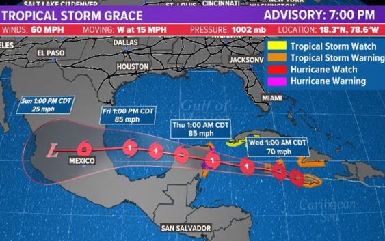
Tracking the tropics: TS Grace forecast to strengthen into a hurricane before landfall in Mexico
We’re keeping our eye on the Gulf of Mexico as the tropics heat up.
HOUSTON — The KHOU 11 Weather team and National Hurricane Center are tracking three different systems in the tropics right now — Tropical Storm Grace, Post Tropical Fred and now Tropical Storm Henri.
Tropical Storm Grace
We’ll start with Tropical Storm Grace, this system will be moving through the northwestern Caribbean Sea during the next day or so, with maximum sustained winds near 60 miles per hour. It’s moving to the west at about 14 miles per hour.
The system will continue to trend across the south-central Gulf of Mexico with an eventual landfall in Mexico.
The National Hurricane Center said Grace is forecast to strengthen into a hurricane when it approaches the Yucatan Peninsula of Mexico on Wednesday night. A lot can change, so we’re keeping a close eye on it.
Where is Grace going:
A general westward to west-northwestward motion is expected for the next several days. On the forecast track, the center of Grace will continue to move away from the western coast of Jamaica overnight. Grace is forecast to move near or over the Cayman Islands early Wednesday, and then approach the Yucatan peninsula of Mexico late Wednesday or early Thursday.
Key messages for Grace
- Hurricane conditions and a dangerous storm surge are expected over portions of the Hurricane Warning area in the eastern Yucatan Peninsula of Mexico beginning late Wednesday night.
- Heavy rainfall across Jamaica, the Cayman Islands and the Yucatan Peninsula is likely to lead to flash and urban flooding. Mudslides are possible in Jamaica.
- Tropical storm conditions are expected over portions of Jamaica Tuesday night and over the Cayman Islands on Wednesday. Hurricane conditions are possible in the Cayman Islands by Wednesday morning. Tropical storm conditions are expected to spread westward from portions of Cuba in the warning area to, possibly, other portions of the southern coast of Cuba in the watch area Tuesday night.
Tropical Depression Fred
Fred made landfall along the Florida panhandle Monday afternoon with max winds of 65 mph. The storm is now weakening over land with a heavy rain and tornado threat across the east coast.
Tropical Storm Henri
Henri has maximum sustained winds near 65 mph with higher gusts.
Henri is currently just southeast of Bermuda. The storm will do a loop around the island before heading out to sea.
Some additional strengthening is forecast during the next couple of days.