- $40 million to go to underserved SC counties for Hurricane Helene recovery. Here's what you need to know.
- Family honors Air Force veteran Derwin Anderson Jr. after he died in June flash floods
- City of Wilmington addresses flooding on New Centre Drive
- Harnett County fire: Two homes damaged
- Medical examiner identifies 13th victim from massive flash flood in San Antonio
Tropical Storm Ida forms with Louisiana landfall favorable
MIAMI — Tropical Storm Ida formed Thursday in the Caribbean and could become a major hurricane by the time it reaches the northern U.S. Gulf Coast over the next several days, forecasters said.
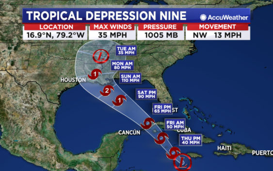
Both the Cuban and Cayman governments have issued tropical storm warnings following the formation earlier of Tropical Depression Nine, which strengthened into Ida Thursday afternoon, according to information on the website of the U.S. National Weather Service.
Air Force Reserve hurricane hunter aircraft data indicate that the depression strengthened to Tropical Storm Ida. The maximum sustained winds are estimated to be 40 mph with higher gusts.
Thursday afternoon, Ida was located about 100 miles west southwest of Negril, Jamaica, and about 130 miles southeast of Grand Cayman.
The storm is traveling northwest at about 14 mph. It is expected to approach western Cuba and the southeastern Gulf of Mexico on Friday, and be a major hurricane by the time it reaches the northern U.S. Gulf Coast on Sunday, the weather service said. The central U.S. Gulf Coast should start to see rain from the depression by early Sunday.
The storm is forecast to deliver anywhere from 6 to 12 inches of rain over parts of Jamaica, Cuba and the Cayman islands. Forecasters warned of possible flash floods and mudslides and a storm surge of as much as 2 to 4 feet above normal, along with “large and destructive waves.”
Copyright © 2021 by The Associated Press. All Rights Reserved.