- EF-1 tornadoes ripped through Cypress, Waller County areas with winds at more than 100 mph, NWS reports
- Houston-area storm damage updates: Clean up continues after NWS says two EF-1 tornadoes and powerful derecho ripped through SE Texas
- Low risk of damaging winds, hail from Saturday storms
- EF 1 tornadoes ripped through Cypress, Waller County areas at more than 100 mph, NWS reports
- Caddo Mounds State Historic Site to celebrate new visitor center, traditional grass house after 2019 tornado
Hurricane Ida threatens Texas, Mexico: Follow the storm, spaghetti models
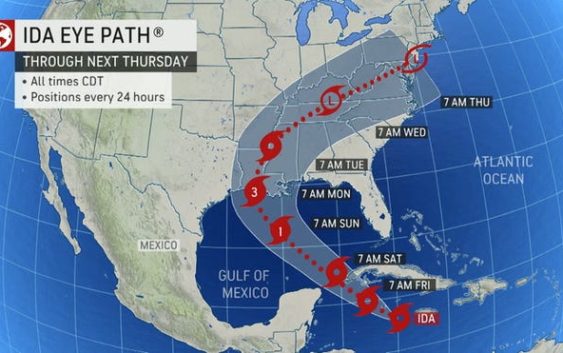
Ida strengthened into from a tropical storm into a hurricane in the Gulf of Mexico Friday.
The storm has maximum sustained winds of 75 mph, according to a 12:15 p.m. Central update from the National Hurricane Center.
Cone of uncertainty: See the latest graphic from the NHC
Satellite images: See latest satellite image from NOAA, for a clearer picture of the storm’s size
The storm is currently 165 miles east of the western portion of Cuba. It is forecast to approach the U.S. northern Gulf Coast on Sunday.
Latest data on Tropical Storm Ida
Here is the latest data on Tropical Storm Ida pulled from the National Hurricane Center’s 4 a.m. Central advisory.
- Location: 30 miles East-Southeast of Isle of Youth
- Maximum sustained winds: 75 mph
- Movement: Northwest at 15 mph
- Pressure: 1,001 MB (millibars)
- When next advisory will be released: The next complete advisory at is at 4 p.m. CT
Watches, warnings and evacuations
- SUMMARY OF WATCHES AND WARNINGS IN EFFECT: A Storm Surge Watch is in effect for… * Sabine Pass to Alabama/Florida border * Vermilion Bay, Lake Borgne, Lake Pontchartrain, Lake Maurepas, and Mobile Bay A Hurricane Watch is in effect for… * Cameron, Louisiana to the Mississippi/Alabama border * Lake Pontchartrain, Lake Maurepas, and Metropolitan New Orleans A Tropical Storm Warning is in effect for… * Cayman Islands * Cuban provinces of Matanzas, Mayabeque, Havana, Artemisa, Pinar del Rio, and the Isle of Youth A Tropical Storm Watch is in effect for… * Mississippi/Alabama border to the Alabama/Florida border. A Storm Surge Watch means there is a possibility of life