- Severe weather leads to fallen trees, car crashes and flooding around the Triangle
- New video shows vehicles being swept away in historic, deadly flash floods in SA on June 12
- $40 million to go to underserved SC counties for Hurricane Helene recovery. Here's what you need to know.
- Family honors Air Force veteran Derwin Anderson Jr. after he died in June flash floods
- City of Wilmington addresses flooding on New Centre Drive
Ida aims to hit New Orleans on Hurricane Katrina anniversary
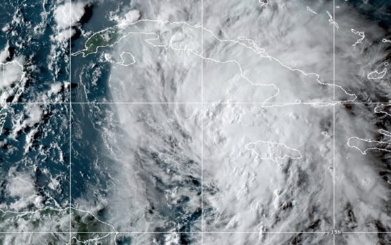
The National Hurricane Center upgraded Ida to a hurricane early Friday Afternoon.
MIAMI — The National Hurricane Center upgraded Ida to a Hurricane early Friday afternoon as it swirled toward a strike on Cuba on Friday. The center also warned the storm could hit Louisiana as a Category 3 hurricane on Sunday.
“The forecast track has it headed straight towards New Orleans. Not good,” said Jim Kossin, a senior scientist with The Climate Service.
New Orleans Mayor LaToya Cantrell called Friday for evacuation of everyone living outside the levee system that protects the area from flooding. She did not say how many people lived there, but urged residents with medical conditions and other special needs to get out early.
“Now is the time,” Cantrell said.
According to the NHC’s latest report Friday, Ida is approaching the Isle of Youth, just over 100 miles south of the Cuban capital of Havana. Earlier forecasts predicted as much as 20 inches of rain could fall in places, making deadly flash floods and mudslides possible, forecasters said.
An even greater danger will then begin over the Gulf, where forecasts were aligned in predicting Ida will strengthen very quickly into a major hurricane, reaching 120 mph (193 kph) before landfall in the Mississippi River delta late Sunday, the hurricane center said.
If that forecast holds true, Ida would hit 16 years to the day since Hurricane Katrina landed as a Category 3 storm with 125 mph (201 kph) winds near the riverside community of Buras in Plaquemines Parish, just down the Mississippi from New Orleans. Buras and New Orleans are among the places that show the highest probabilities for getting hit with hurricane-force winds from Ida, the national hurricane center said.
People were getting ready in New Orleans on Friday, lining up for groceries, gas and ice, and the city was offering sandbags.
Traffic snarled at entrances to a New Orleans Costco, where dozens of cars were backed up at the gas pumps and shoppers wheeled out carts stacked with cases of bottled water and other essentials.
Retired police officer Wondell Smith, who worked on the police force 16 years ago when Katrina hit, said he and his family were planning to stay, but were also getting ready to head farther inland if the forecasts worsened. He loaded water, bread and sandwich meat into his SUV.
“I know what that looks like,” Smith said, referring to the potential devastation. “This is my first time being home in 34 years of service,” he added. “And I want to be prepared.”
Kickoff for Saturday’s preseason game between the Arizona Cardinals and the Saints at the Superdome was moved up seven hours to avoid the weather, to a noon Central Time start after consultation with city and federal officials and the National Weather Service.
Friday morning, Ida’s maximum sustained winds swiftly rose from 40 mph (65 kph) to 65 mph (100 kph) as it approached Cuba. Tropical storm-force winds extended as far as 90 miles (150 kilometers) from the center.
“Ida certainly has the potential to be very bad,” said Brian McNoldy, a hurricane researcher at the University of Miami. “It will be moving quickly, so the trek across the Gulf from Cuba to Louisiana will only take 1.5 days.”
Louisiana has declared a state of emergency. Category 3 hurricanes are capable of causing devastating damage.
“Unfortunately, all of Louisiana’s coastline is currently in the forecast cone for Tropical Storm Ida, which is strengthening and could come ashore in Louisiana as a major hurricane as Gulf conditions are conducive for rapid intensification,” said Gov. John Bel Edwards.
“By Saturday evening, everyone should be in the location where they intend to ride out the storm,” the governor added.
A hurricane watch was in effect from Cameron, Louisiana, to the Mississippi-Alabama border — including Lake Pontchartrain, Lake Maurepas and metropolitan New Orleans.
Dangerous storm surge was also possible along the Gulf Coast. If it pushes a storm surge at high tide, Ida could overlap some levees, with 7 to 11 feet (2.1 to 3.4 meters) of water predicted from Morgan City, Louisiana, to Ocean Springs, Mississippi.
“There is an increasing risk of life-threatening storm surge, damaging hurricane-force winds, and heavy rainfall Sunday and Monday, especially along the coast of Louisiana,” the hurricane center said.
The mayor of Grand Isle, a Louisiana town on a narrow barrier island in the Gulf, said a voluntary evacuation late Thursday would become mandatory on Friday.
By the time it reaches the central Gulf Coast Sunday, it could dump 8 to 16 inches (15 to 30 centimeters) of rain, with 20 inches in isolated areas, from southeast Louisiana to coastal Mississippi and Alabama through Monday morning. More heavy rains are likely across Mississippi when Ida moves inland, causing “considerable flash, urban, small stream, and riverine flooding,” the hurricane center said.
Associated Press contributors include Melinda DeSlatte in Baton Rouge, La., and Seth Borenstein in Kensington, Md.