- Why leaders are urging NC residents to start hurricane prep now
- Storms could produce hail, damaging winds south of Charlotte
- Large hail and strong winds cause damage in San Marcos and the Hill Country
- Severe weather possible Friday afternoon across Cape Fear
- Live radar, updates: Severe weather possible Thursday evening for Central Texas
Ida intensifies in the Gulf, expected to make landfall in Louisiana as a major hurricane
Hurricane Ida is forecast to go through rapid intensification as it nears the Louisiana coast tomorrow. A Category 3 or 4 hurricane is possible at landfall.
CHARLOTTE, N.C. — The historic peak of hurricane season is September 10, but it is late August and September that some of the more notable storms have formed and even impacted the Carolinas.
Hurricane Ida is expected to impact the northern Gulf coast tomorrow. Here in the Carolinas, notable impacts aren’t expected but we could have additional cloud cover and rain mid-next week.
Elsewhere, we have a newly-formed tropical depression and two areas to watch.
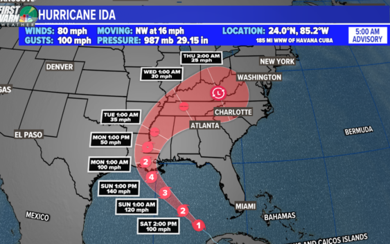
Hurricane Ida
Location: 510 miles southeast of New Orleans, Louisiana
Potential Impacts: United States northern Gulf coast: including Louisiana, Mississippi, Alabama, and the western Florida panhandle
What has happened:
On August 26th, Tropical storm Ida was born and it strengthened to a Category 1 hurricane just after 1 p.m. August 27th. Shortly after, the storm made landfall on the Isle of Youth, the second-largest Cuban island. The second landfall was near Pinar Del Rio, Cuba with sustained winds at 80 mph. It was over the island for about 3-4 hours.
The Forecast:
The storm is expected to rapidly intensity to a Category 4 major hurricane over the weekend. Storm surge and hurricane warnings have been issued for the northern Gulf coast.
Saturday: Ida will go into a process called “rapid intensification” when it moves into the middle of the Gulf of Mexico. This is a warm spot of water that hurricanes historically thrive and grow in. Two examples are Hurricane Katrina (2005) and Hurricane Michael (2018). So what will happen?
- Central pressure will drop which strengthens the wind field
- The eye wall will form turning Ida into a classic looking strong hurricane
- Sustained winds will increase over 35 mph in a 24 hour period.
- Hurricane Ida will become a major hurricane peaking up to Category 4 strength of 140+ mph
The latest track from the National Hurricane Center suggests a Category 3 or 4 major hurricane will make landfall along the Louisiana coast by around 6 p.m. Sunday.
Storm Surge:
Historically, storm surge is the largest threat to life and property within a tropical cyclone. The water level rise due to Ida is expected to be the worst from Morgan City, LA to the mouth of the Mississippi River where the water levels could peak between 10 to 15 feet.
A Storm Surge Warning is in effect east of Rockefeller Wildlife Refuge, Louisiana to the Mississippi/Alabama border, Vermilion Bay, Lake Borgne, Lake Pontchartrain, and Lake Maurepas.
A Storm Surge Watch is in effect for Sabine Pass to Rockefeller Wildlife Refuge, Louisiana, and Mobile Bay.
Warnings and Watches:
A Hurricane Warning is in effect for Intracoastal City, Louisiana to the Mouth of the Pearl River, Lake Pontchartrain, Lake Maurepas, and Metropolitan New Orleans.
A Hurricane Watch is in effect for Cameron, Louisiana to west of Intracoastal City, Louisiana, the mouth of the Pearl River to the Mississippi/Alabama border.
A Tropical Storm Warning is in effect for Cameron, Louisiana to west of Intracoastal City, Louisiana, the mouth of the Pearl River to the Mississippi/Alabama border.
A Tropical Storm Watch is in effect for the Mississippi/Alabama border to the Alabama/Florida border.
Rainfall:
One of the worst features of a hurricane is the amount of rain it brings to an area. Louisiana is incredibly low in elevation for flooding and storm surge is magnified. The peak rain around the core is estimated to be up to 15″+. Also 3-10″ of rain will spread across Mississippi.
Tropical Depression Ten
As of 5 a.m. Saturday, Tropical Depression Ten has formed in the central Atlantic Ocean. The system is expected to drift northward over the next few days when it could become a tropical storm.
It’s expected to stay well east of the Lesser Antilles. Next storm name on the list is Julian.
Wave Number 1: Invest 97-L
Location: Central Atlantic
Development Chance: 40% next two days and 60% within the next five days
Development potential has remained steady for Invest 97-L over the past 24 hours. Conditions are marginally favorable for development this weekend, so a tropical depression could form as it drifts slowly eastward.
This system is no concern to the United States.
Wave Number 2
Location: over Africa
Development Chance: 0% next two days and 40% within the next five days
This is a new area to monitor in the Atlantic Basin. A tropical wave is expected to emerge off the African coast by mid-next week. Conditions will be marginally conducive for development.
It’s much too early to know what could happen with this disturbance. Stay tuned for updates!