- Hurricane survival kit: How to keep your family safe when a hurricane hits
- Houston-area storm damage: Update on status of schools, power outages and resources for storm victims
- EF-1 tornadoes ripped through Cypress, Waller County areas with winds at more than 100 mph, NWS reports
- Houston-area storm damage updates: Clean up continues after NWS says two EF-1 tornadoes and powerful derecho ripped through SE Texas
- Low risk of damaging winds, hail from Saturday storms
Hurricane Ida expected to be 'extremely dangerous' storm when it makes landfall Sunday
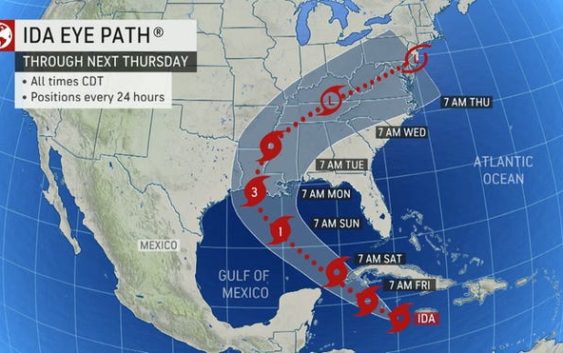
Hurricane Ida continues to rapidly strengthening as it moves over the Gulf of Mexico on Saturday, according to the National Hurricane Center.
The storm has maximum sustained winds of 105 mph, according to a 10 p.m. Central update from the National Hurricane Center.
The storm is located 235 miles southeast of Houma, Louisiana, and is moving northwest at 16 mph. A northeastward turn is forecast by Monday night.
Cone of uncertainty: See the latest graphic from the NHC
Satellite images: See latest satellite image from NOAA, for a clearer picture of the storm’s size

The center of the storm is forecast to move over the central Gulf of Mexico through Saturday night before making landfall along the coast of Louisiana on Sunday.
The National Hurricane Center warned, “Rapid strengthening is forecast during the next 12 to 18 hours and Ida is expected to be an extremely dangerous major hurricane when it approaches the northern Gulf coast on Sunday.”
Hurricane-force winds extend 40 miles from the center and tropical storm-force winds extend 140 miles from the center.
Heavy rainfall will begin to impact the Louisiana coast Sunday morning, spreading northeast into the Lower Mississippi Valley later Sunday into Monday. Total rainfall of 8 to 16 inches with isolated amounts of 20 inches are possible across southeast Louisiana into southern Mississippi through Monday. According to the National Hurricane Center, this is likely to result in life-threatening flash flooding.
Latest data on Hurricane Ida
Here is the latest data on Hurricane Ida pulled from the National Hurricane Center’s 10 p.m. CT Saturday advisory.
- Location: 235 miles southeast of Houma, Louisiana
- Maximum sustained winds: 105 mph
- Movement: Northwest at 16 mph
- Pressure: 964 MB (millibars)
Watches, warnings and evacuations
- A Storm Surge Warning is in effect for… * East of Rockefeller Wildlife Refuge Louisiana to the Alabama/Florida border * Vermilion Bay, Lake Borgne, Lake Pontchartrain, Lake Maurepas, and Mobile Bay
- A Hurricane Warning is in effect for… * Intracoastal City Louisiana to the Mouth of the Pearl River * Lake Pontchartrain, Lake Maurepas, and Metropolitan New Orleans
- A Tropical Storm Warning is in effect for… * Cameron Louisiana to west of Intracoastal City Louisiana * Mouth of the Pearl River to the Alabama/Florida border
- A Storm Surge Warning means there is a danger of life-threatening inundation, from rising water moving inland from the coastline, during the next 36 hours in the indicated locations.
- A Hurricane Warning means that hurricane conditions are expected somewhere within the warning area. A warning is typically issued 36 hours before the anticipated first occurrence of tropical-storm-force winds, conditions that make outside preparations difficult or dangerous. Preparations to protect life and property should be rushed to completion.
- A Tropical Storm Warning means that tropical storm conditions are expected somewhere within the warning area within 36 hours.