- $40 million to go to underserved SC counties for Hurricane Helene recovery. Here's what you need to know.
- Family honors Air Force veteran Derwin Anderson Jr. after he died in June flash floods
- City of Wilmington addresses flooding on New Centre Drive
- Harnett County fire: Two homes damaged
- Medical examiner identifies 13th victim from massive flash flood in San Antonio
Tropical Storm Nicholas in the Gulf, several more waves with chances to develop
We’re deep into the most active month of hurricane season and the WCNC Charlotte weather team is tracking five systems.
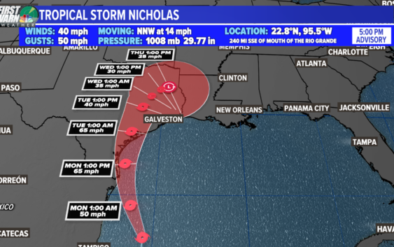
CHARLOTTE, N.C. — Tropical Storm Nicholas is the newest named storm in the Atlantic basin. The 14th named storm this hurricane season is currently a weak tropical storm with maximum sustained winds of 40 mph in the southern Gulf of Mexico.
Nicholas is moving towards the U.S. Gulf coast with a forecast track over Texas by early Tuesday morning. The tropical storm will likely intensify and mature over the warm waters of the Gulf before its potential landfall, which will only exacerbate the situation if for storm surge, tropical storm force winds and flash flooding. Nicholas may even stall out over the region cause additional flooding to some areas already hard hit from Ida.
The biggest threat with this system is rainfall and flooding. The disturbance will continue to produce heavy rain across portions of southern Mexico today, which may lead to flash flooding and mudslides.
Heavy rainfall will overspread into coastal portions of Texas and Louisiana Sunday into Monday, potentially resulting in areas of flash, urban, and isolated river flooding.
One of the reasons why is due to the fact that Nicholas could stall across the southern United States as it moves inland. Rainfall totals will peak near 5-10 inches in spots with maximum total of 15 inches where the heaviest bands set up.
The combination of high tide and storm surge will allow for a water level rise of 2 to 4 feet from the mouth of the Rio Grande to High Island, Texas, Baffin Bay, Corpus Christi Bay, Aransas Bay, San Antonio Bay, Matagorda Bay, and Galveston Bay.
A Storm Surge Watch is in effect for the mouth of the Rio Grande to High Island, Texas.
A Tropical Storm Warning is in effect for much of the Texas coastline from south of Brownsville northward through Corpus Christi into Brazosport.
A Tropical Storm Watch is in effect for Houston and areas just inland from the immediate coast.
We’re watching a second area near the Bahamas. This is a weak tropical wave interacting with an upper-level trough that is producing disorganized showers and storms.
Gradual development is possible and the National Hurricane Center is giving it a 50% chance of development over the next five days.
Long-term forecast models indicate the system will stay away from the United States east coast due to a strong ridge of high pressure and approaching cold front. This is subject to change, so we’ll monitor closely.
Nevertheless, this kind of tropical activity in the western Atlantic could elevate our rip current risk again for the coastal Carolinas. It’ll depend on eventual track and strength.
Elsewhere, there are two additional tropical waves near Africa. One is bringing locally heavy rain to the Cabo Verde Islands and one is expected to emerge off the African coast this week.
The area shaded in yellow has weaken to zero chances of development. High wind shear is likely the reason for its demise. However, there is a possibility as it breaks down, its energy essentially merges into the area shaded in orange with a (60%) chance of formation over the next five days.
The next two names on the 2021 Atlantic hurricane list are Odette and Peter.