- Severe weather leads to fallen trees, car crashes and flooding around the Triangle
- New video shows vehicles being swept away in historic, deadly flash floods in SA on June 12
- $40 million to go to underserved SC counties for Hurricane Helene recovery. Here's what you need to know.
- Family honors Air Force veteran Derwin Anderson Jr. after he died in June flash floods
- City of Wilmington addresses flooding on New Centre Drive
How do I know if I need to evacuate when there's a hurricane?
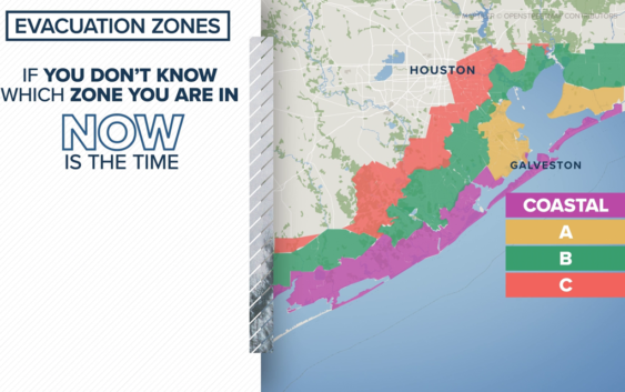
The Houston-Galveston Area Council created a ZIP code system for evacuations based on the threat of a hurricane’s storm surge.
HOUSTON — Because the Gulf Coast is no stranger to hurricanes, our area has a detailed plan in place to get people out of the path of danger. The Houston-Galveston Area Council created this ZIP code system for evacuations based on the threat of a hurricane’s storm surge.
As of Monday morning, no evacuation advisories or orders have been issued for Tropical Storm Nicholas.
City and county leaders are the ones who determine if and when to issue orders and, of course, KHOU 11 News will relay that information on-air, online and on our mobile app.
There are four zones: coastal is purple, A is yellow, B is green and C is orange.
If you don’t know which zone you’re in, now’s the time to figure it out so you’ll be ready if it happens. You can find out which ZIP codes are in which zone here.
You should also determine in advance which route you would take to evacuate.
If and when your zone is advised to evacuate, this map comes into play. Wherever home is, look at the closest route to you, which direction you should head and which highways or freeways you should travel. The idea is to get people out of harm’s way quickly and efficiently.
If you want to review any of this, all of the information is available on the council’s website too.