- EF-1 tornadoes ripped through Cypress, Waller County areas with winds at more than 100 mph, NWS reports
- Houston-area storm damage updates: Clean up continues after NWS says two EF-1 tornadoes and powerful derecho ripped through SE Texas
- Low risk of damaging winds, hail from Saturday storms
- EF 1 tornadoes ripped through Cypress, Waller County areas at more than 100 mph, NWS reports
- Caddo Mounds State Historic Site to celebrate new visitor center, traditional grass house after 2019 tornado
Sam rapidly intensifies into a Category 2 hurricane, major expected soon
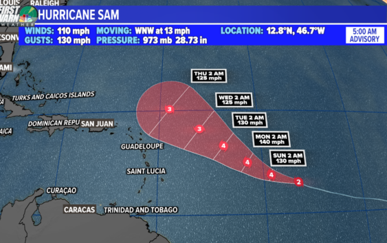
Hurricane Sam is strengthening quickly and will become a major hurricane today. Elsewhere, we have two areas to watch.
CHARLOTTE, N.C. — Hurricane Sam has rapidly intensified to a Category 2 with maximum sustained winds of 110 mph. Rapid intensification is defined as a wind increase of 35 mph or more over a 24-hour period.
The storm will become a major hurricane as early as today as it continues its trek toward the west-northwest. Long-range forecast models indicate a strong trough of low pressure will keep the storm away from the United States east coast.
Depending on how strong the storm eventually becomes and how close it tracks, the swells could increase our rip current risk along the eastern seaboard. You can trust the WCNC Charlotte weather team to keep you updated on any changes.
The other named storm in the Atlantic Basin is Subtropical Storm Teresa. This will be a short-lived system that will have no impact to the United States. A subtropical storm is a cyclone that has both atmospheric influences, such as a cold front, as well as tropical characteristics.
Elsewhere, we have two areas of interest to watch. A low pressure system associated with the remnants of Peter is located south of Bermuda. There is a small, limited potential for development over the next 5 days.
Eventually, strong wind shear looks to break this system apart. Right now, the National Hurricane Center is giving it a 20% chance of formation.
Lastly, we have a new tropical wave expected to move off the west coast of Africa by Monday. Environmental conditions will be marginally conducive for development once it does.
A tropical depression is likely to form mid-next week. Right now, the National Hurricane Center is giving it a 50% chance of development.