- Mosquito activity on the rise due to rainfall, flooding across Texas
- Volunteers help Conroe community clean up in wake of flooding in Montgomery County
- Why leaders are urging NC residents to start hurricane prep now
- Storms could produce hail, damaging winds south of Charlotte
- Large hail and strong winds cause damage in San Marcos and the Hill Country
Tropical Storm Victor forms in the Atlantic Basin
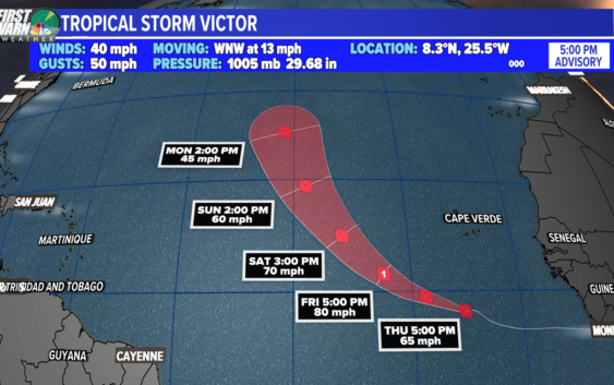
Victor became the twentieth named storm of the 2021 Atlantic hurricane season.
CHARLOTTE, N.C. —
Tropical Storm Victor
As of 5 p.m. Wednesday, Tropical Storm Victor formed in the eastern Atlantic Ocean. Victor is only the third time in history we have had a name starting with the letter ‘V’.
By Thursday night or Friday morning, Victor will become a hurricane and will reach its peak intensity by Saturday morning. Steady strengthening is a sure thing with prime water temperatures in the storm’s path.
By the middle of the weekend, Victor will weaken below hurricane status and will eventually wind down in the middle of the Atlantic.
Hurricane Sam
Hurricane Sam continues to maintain its major hurricane status in the Atlantic. Sam’s eyewall has become cloud-filled but it is forecasted to drop in pressure more and increase its winds jump deeper into strong category 4 strength.
Since it is currently missing its eye, we will see some intensity fluctuations as it goes into its eye replacement cycle. By Friday it should start to weaken more as wind shear is in line to knock Sam down a few pegs by the end of the weekend.
By Saturday, Sam is forecast to turn northeast and will be downgraded to a category one by Sunday night. The United States and Bermuda is lucky we had the right systems blocking/protecting the U.S. from the last several storms.
Is Sam the strongest hurricane this season?
Yes. Sam almost reached Category 5 strength, but then weakened to Category 4 strength before returning to where it is today. Ida peaked at 140 mph and is currently the most destructive of the season and the first hurricane to make landfall in the United States (6 tropical storms have also made landfall).
Larry currently has the highest A.C.E. (Accumulated Cyclone Energy) which accounts for strength and duration. Larry was a named storm for over 10 days, but Sam is forecasted to surpass that time frame by this weekend.
Risks for Sam:
- Large swells for Bermuda
- Life-threatening rip currents on the east coast
Other Tropical Waves:
There are two waves out in the Atlantic Ocean, but neither is likely to develop.
Wave #1
An area of low pressure associated with the remnants of Peter located several hundred miles south of the coast of Newfoundland continues to produce disorganized showers and thunderstorms.
This system is moving into an area with cooler ocean waters and higher wind shear. Significant development is not anticipated. The National Hurricane Center is only giving it a 10% of formation.
Wave #2 (Invest 91-L)
Showers and thunderstorms remain disorganized in association with a trough of low pressure located several hundred miles southwest of the Cabo Verde Islands.
Some slow development of this system is possible during the next couple of days while it drifts west-northwestward across the central tropical Atlantic. The National Hurricane Center is giving it a 30% of formation.
Ever since Ida, all storms have formed out in the Atlantic and most have been short-lived. Larry and Sam were the 3rd and 4th major hurricanes of the season.
With only one name left, we’ll most likely be into our supplemental storm list very soon.