- Flooding lingers in Liberty County neighborhoods near Trinity River with more rainfall expected
- North Carolina behind on hurricane preparedness, study shows
- North Carolina way behind on hurricane preparedness, study shows
- New hurricane preparedness report doesn't rank North Carolina well
- New hurricane preparedness report doesn't rank North Carolina well
Kentucky hit by EF-4 tornado, WRAL Severe Weather Center unpacks rare December storms
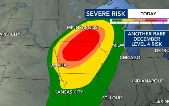
Five days have passed since Friday’s deadly tornado outbreak, and while such severe weather risk in December is quite the rarity, it’s hard to believe a portion of the country is under another Level 4 risk on Wednesday.
A Recent preliminary survey has been released classifying the tornado that blasted western Kentucky last Friday as an EF-4. Winds reached 190 mph over some 128 miles on the ground.
An EF-5 is qualified by winds over 200 mph.
Friday’s outbreak saw numerous tornadoes. Even though a few tornadoes are possible in Iowa and Minnesota later Wednesday, the greatest impact could be from widespread damaging winds, as storms may travel at roughly 60 to 80 mph.

Wednesday’s Level 4 risk in Iowa and Minnesota is the eighth Level 4 risk to be issued nationwide in December since 2006. Wednesday’s storms may very well rewrite Iowa and Minnesota’s weather history book, as Minnesota has never observed a tornado in December and Iowa has only observed four since 1980.
December in the Midwest usually involves snow, not tornadoes. Wednesday, however, will involve both as northern Iowa and much of Minnesota, the area highlighted by the severe weather risk, currently have measurable snowfall on the ground.

What could be influencing not only Friday’s, but Wednesday’s, severe weather? The answer lies within both the current phase of the El Niño–Southern Oscillation (ENSO) and above-normal sea surface temperatures in the Gulf of Mexico.
What is the El Niño–Southern Oscillation (ENSO) in a nutshell?
The earth’s climate undergoes cyclical changes regularly, like seasonal patterns that occur annually. There are less-regular cycles with durations from a few months up to several decades and, while their cause is not clearly understood, their changes in one part of the world can have well-defined effects on global weather patterns.
The cycles are generally defined by changes in air pressure, sea temperature and wind direction over oceans.
The El-Niño-Southern Oscillation (ENSO) is one such cycle that has three phases defined by sea surface temperatures in the equatorial Pacific Ocean.
We have the warm phase (El Niño), the cold phase (La Niña) and the neutral phase, ENSO Neutral. Currently, La Niña conditions are present and may be one of the factors contributing to the jet stream’s increased volatility because it makes the normal easterly winds along the equator even stronger.

This corridor of cooler water temperatures and the corresponding air mass in the equatorial Pacific Ocean causes the jet stream to flow in a more volatile pattern from the north to the south (meridional flow) versus the more tranquil pattern from the west to the east (zonal flow).

With this rather volatile jet stream pattern comes low pressure systems that can not only form but also strengthen quite rapidly. Low pressure systems traveling across the country are a normal and almost bi-weekly occurrence in December.
Since these systems are a normal occurrence, La Niña’s enhancement of these lows is one potential reason why they are stronger and producing severe storms. Warmer sea surface temperatures present in the Gulf of Mexico also provide that extra enhancement in the environment, allowing severe storms to develop.

As low-pressure systems travel across the country, they draw up warm and moist air from the deep south and Gulf of Mexico. Since sea surface temperatures are warmer in the gulf, the air mass coming north from it is similar to an air mass in the spring versus the winter.

The warmer air temperatures and higher dew point temperatures are two of the four ingredients needed to produce severe weather.
The remaining two ingredients, lift and spin in the atmosphere, come from the strong areas of low pressure. These were present in last Friday’s storm system and are present in Wednesday’s storm system.

While these severe storms will not impact us locally, WRAL’s team of meteorologists is here to explain why these storms are happening in the first place. Both La Niña and above-normal sea surface temperatures in the Gulf of Mexico look to be the reason behind why we are seeing this very active stormy period.