- Mosquito activity on the rise due to rainfall, flooding across Texas
- Volunteers help Conroe community clean up in wake of flooding in Montgomery County
- Why leaders are urging NC residents to start hurricane prep now
- Storms could produce hail, damaging winds south of Charlotte
- Large hail and strong winds cause damage in San Marcos and the Hill Country
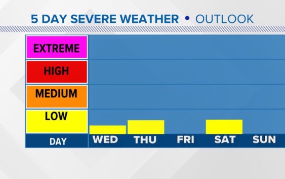
Low-end severe weather chances Thursday & Saturday
Stay weather aware the next few days.
CHARLOTTE, N.C. — The late December heatwave will help fuel the risk for some scattered strong to severe storms over the next four days. While the risk is low for now, it’s a good idea to stay weather aware over the next few days. Here’s a breakdown of what, when, and where to expect some strong storms in the next few days.
Timing:
There will actually be two main chances for strong to severe storms between now and the end of the weekend.
- The first chance will be late Wednesday night into early Thursday morning. With a strong Jetstream helping and overnight lows only dropping into the low 60s there will be opportunities for strong to severe storms to last into the early hours of Thursday. While the highest risk remains to the west some of what’s left of those storms could arrive 4 a.m. to 8 a.m. Thursday in the Carolinas.
- Chance number two arrives late Saturday on New Year’s Day. This system looks much strong for our are to me. The track takes it right ver the heart of the area. So of the two chances, this one on Saturday could be the higher risk day. The storm also looks to be moving in during the max heating of the day on Sunday with high temperatures in the mid-70s.
Keep in mind even though these are the two main changes if conditions change we might see chances again Thursday afternoon. It’s all going to depend on the timing and any surges in the sunshine along with warm and humid temperatures that lead to higher ingredients for severe storms.
Location:
Late Wednesday and Thursday the risk looks confined to areas to the south and west of the Piedmont. The question will be if we see new storms in the afternoon or if the front clears the area. It appears the worst ingredient for strong storms will be along and south of I-85.
Impacts:
The primary impacts for all the events will be straight-line winds. Though there is a low-end tornado risk of conditions set up just right. Those conditions right now appear more likely south of I-85 but anywhere east of the mountains could be at risk. Then all bets are for the Saturday system. The significant tornado parameter is slightly elevated in those areas early Thursday morning.
The real question and what is still very uncertain is how the parameters will line up on Saturday. This is why it is vital to always have a severe weather plan, with ways to get warnings and places for shelter. With it being a holiday weekend and out of our “normal” severe weather season I don’t want you to be caught off guard by the risk.