- ‘Somewhere around $5 million’ | Rock Hill officials see major storm damage costs
- The deadliest tornadoes to ever hit Austin
- Whiteville resident recalls events from Tuesday nights tornado
- Tornado damage reported in southern NC after Tuesday's severe storms
- If your home floods, here are steps you can take to address mold
Tornado warning, severe thunderstorm warning for Harris, Montgomery counties
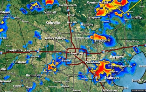
A severe thunderstorm warning has just been issued in central Harris County and southeastern Montgomery County until 4 p.m.
HOUSTON — A tornado warning has been issued for southeastern Harris County until 3:45 p.m.
The National Weather Service reports a severe thunderstorm capable of producing a tornado was spotted near Deer Park at 3:12 p.m., moving north at 20 to 25 mph.
KHOU 11 Meteorologist Tim Pandajis said it’s radar-indicated and nothing has been confirmed on the ground. He said Baytown, Channelview, La Porte and nearby areas should stay weather aware.
LOCAL FORECAST: Rain returns this weekend
Timeline of wet weather in Houston area this weekend:
- Saturday: While parts of Houston have seen intermittent showers, areas to the northeast have been getting inundated with heavy rain. Pandajis reported radar estimates of nearly 5 inches in some spots by 1:15 p.m.
Temperatures will stay warm for the weekend with high humidity — a dramatic difference from Friday when highs were in the 50s.
- Sunday: A few overnight storms could produce about an inch of rain. The more active severe threat moves in between 2:30 and 6:30 a.m. After that, the overall trend for Sunday will be less rain as a new cold front moves through. The rain should move offshore by 2 p.m.
The main severe threat will be for periods of strong wind and localized heavy rain. There is also a marginal risk to see a spin up by way of a waterspout, and brief tornado or two.
A few spotty showers could linger in the Houston Metro for the Texans tailgate. What else will linger? The warmth! Temps hover in the mid 70s most afternoon. The record stands at 80 degrees so likely in the clear but still not very winter-like temps.
You can track the rain all weekend long using our live interactive radar.
Also, follow the KHOU 11 Meteorologist team for live updates: