- WATCH: Video Shows Confirmed Tornado touches down in Columbus County
- Residents begin clean up after storms, apparent tornado roll through NC Tuesday
- NC State researchers find increased fecal contamination in coastal waters due to sunny day flooding
- Flooding lingers in Liberty County neighborhoods near Trinity River with more rainfall expected
- North Carolina behind on hurricane preparedness, study shows
Tornado Watch for Harris, Montgomery, 8 other counties until midnight
The National Weather Service Storm Prediction Center has issued the watch for much of Southeast Texas. Here’s where that watch area covers.
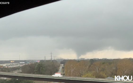
HOUSTON — A Tornado Watch continues for much of Southeast Texas until midnight. Ten counties are covered in the watch area: Harris, Montgomery, Chambers, Liberty, San Jacinto, Waller, Grimes, Trinity, Polk and Walker counties.
A Tornado Watch means conditions are favorable for the development of tornadoes in the area. During the watch, you should review your tornado safety procedures and be prepared to move to a safe place if threatening weather approaches.
Saturday’s watch came after multiple Tornado Warnings were issued as storms moved north-by-northeast across the Houston area.
Radar confirmed two tornadoes touched down — in the Humble area and Liberty County — according to KHOU 11 Meteorologist Tim Pandajis. No major damage was reported.
If you’re in the path of a tornado, you should seek shelter in an interior room, take cover and stay away from doors and windows.
LOCAL FORECAST: Storms possible all weekend
- Sunday: A few overnight storms could produce about an inch of rain. The more active severe threat moves in between 2:30 and 6:30 a.m. After that, the overall trend for Sunday will be less rain as a new cold front moves through. The rain should move offshore by 2 p.m.
The main severe threat will be for periods of strong wind and localized heavy rain. There is also a marginal risk to see a spin up by way of a waterspout, and brief tornado or two.
A few spotty showers could linger in the Houston Metro for the Texans tailgate. What else will linger? The warmth! Temps hover in the mid 70s most afternoon. The record stands at 80 degrees so likely in the clear but still not very winter-like temps.
You can track the rain all weekend long using our live interactive radar.
Also, follow the KHOU 11 Meteorologist team for live updates: