- Rock Hill storm damage costs are 'somewhere around $5 million.' That number doesn't include damage to personal property
- Rock Hill storm damage costs are 'somewhere around $5 million.' That number doesn't include damage to personal property
- ‘Somewhere around $5 million’ | Rock Hill officials see major storm damage costs
- The deadliest tornadoes to ever hit Austin
- Whiteville resident recalls events from Tuesday nights tornado
Orange County Schools moves to remote, Duke activates severe weather policy
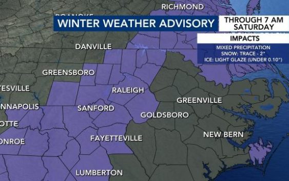
Raleigh, N.C. — WRAL’s team of meteorologists is tracking the most significant winter storm to impact the Triangle in over three years.
What to know:
- Rain falling across the area Thursday afternoon could turn into a wintry mix north of the Triangle around sunset.
- Light snow accumulation will be possible Thursday night along the North Carolina-Virginia line.
- Temperatures will dip into the 20s Thursday night and Friday, and roads will be treacherous throughout the entire day.
- The Triangle is under a winter storm watch Thursday night through Saturday morning, with areas to the east under a winter storm warning. See all alerts.
- Areas along the North Carolina coast, which could see the biggest impacts from the storm, are under an ice storm warning.
- Between 1 and 3 inches of snow are expected to fall in the Triangle on Friday, with less snow to the northwest. Counties east and northeast of Raleigh could see between 2 to 5 inches by Saturday morning.
- Wake, Durham and Johnston county public schools are among those closed on Friday. See all closings and delays.
Track rain and snow with the DualDoppler5000 | Download the WRAL Weather app to get alerts | Monitor school closings | Get a live look at NC weather cameras
6:30 p.m.: Orange County Schools will be closed on Friday. All on-site activities, including athletic practices and events and driver’s education, has been canceled through Sunday.
Meanwhile, Duke University and Duke University Health System has activated its severe weather policy for 7 a.m. through 10 a.m. on Friday. All on-site classes before 10 a.m. will be canceled or moved to online and classes after 10 a.m. will continue as scheduled.
Duke Health clinics, including COVID testing sites and vaccination sites, could delay opening or closing based on evolving weather conditions Friday.
Other area hospitals, such as UNC Rex, saiid while they’re encouraged by lowering snowfall predictions in the Triangle, any ice or freezing rain could be disruptive.
UNX Rex director of emergency management Alan Foster said across the UNC Health System, many staff will stay at the hospital or nearby hotels to make sure they’re able to work their shifts through the storm.
“We had about a 25 percent reduction in the schedule [Wednesday] but that was all voluntary surgeries that could safely be postponed,” said Foster. “We’ll certainly maintain the necessary schedules for procedures and certainly the emergency cases. WE have plans in place to maintain that regardless of the weather.”
Foster added that UNC Health has several medical facilities east of Raleigh that could see more serious weather, and encouraged anyone with a procedure planned to communicated with the medical staff about possible cancelations.
Thursday 5 p.m.: Snowflakes have begun to fall in South Hill, Va., as the changeover from rain to winter weather continues.
“Up in our northern counties, we’re seeing a little bit of light snow falling,” said WRAL meteorologist Mike Maze.
In the Triangle, MAKO Medical COVID-19 testing sites will be closed on Friday, while Wake County COVID-19 testing and vaccination sites will be closed Friday and Saturday. People with an appointment at a Wake testing site will receive an email to let them know they can returned to the scheduled appointment site on Monday and Tueday when the appointment will be honored.
Wake sites will continue to be open until 7 p.m. on Thursday.
MAKO Medical will close its sites at PNC Arena, the Mudcats Stadium, WakeMed Soccer Park and Word of God. The sites will reopen on Monday, according to a statement from the company.
During a press conference on Thursday afternoon, Gov. Roy Cooper said National Guard personnel will be on standby to help people stranded in what are expected to be frigid temperatures on Friday night.
“It’s going to get very cold, and if you have people who have lost power, this could be a dangerous situation for them so it’s really important that our counties are getting ready with some potential warming shelters if needed. As North Carolinians do – as they always do – let’s look out for each other,” said Cooper.
Thursday, 4 p.m.: Snowfall is imminent in central North Carolina, according to WRAL meteorologist Kat Campbell.
Areas around South Hill are already bordering freezing temperatures, so the change could start soon in areas north of Raleigh. The northern part of the WRAL viewing area is expected for rain to change to wintry mix from 4 to 6 p.m. meanwhile the transition timeline in the Triangle will be tween 7 and 9 p.m.
Campbell said after midnight, precipitation will be lightening up.
“We may still squeeze out some snowflakes, some sleet pellets in our southern counties. It’s less likely though to add up to anything significant,” said Campbell.

But, no matter what falls on Thursday, with low temperatures falling below freezing, any wet spots on the road will freeze.

The latest snow forecast as of 4 p.m. showed the Triangle and down toward Fayetteville getting up to an inch-and-a-half of snow for Thursday and Friday. Those numbers go up for areas around Roxboro, Rocky Mount, Wilson and Goldsboro with 2 to 4 inches of snow forecasted.
Thursday, 2 p.m.: North Carolina State University will operate on a two-hour delay on Friday. All classes scheduled before 10 a.m. are canceled.
In Fayetteville, a shelter will open at 4 p.m. at Smith Recreation Center, 1520 Slater Ave. It will remain open through noon on Sunday. Meals will be served, but pets are not allowed. Everyone will be screened for COVID-19 upon arrival, and isolation areas will be available for those who test positive or have COVID-19 symptoms. Social distancing will be enforced and masks are required inside the shelter.
Thursday noon update:
Rain is now falling steadily across the viewing area. That rain will change over to a wintry mix by 4 to 6 p.m. in our northern counties, especially those north of Durham, according to WRAL meteorologist Elizabeth Gardner. Snowflakes and light accumulation will be possible Thursday night as far south as Wake County.
Temperatures will plunge into the 20s overnight and on Friday, so roads will become treacherous anywhere they are wet, but especially north of Raleigh.
“We can have slick roads anywhere, because a lot of folks will continue to see rain into the early morning hours of Friday, and temperatures will stay very cold,” Gardner said.
People should prepare to “hunker down” Thursday night, Gardner added.
There will be a break in precipitation Friday morning, with redevelopment occurring around 10 a.m. or 11 a.m., and snow slowly spreading into the Triangle area from the east.
Since Friday’s snow will be coming from a coastal low, models are calling for very little snow from Durham to Roxboro and points to the northwest, which isn’t the usual case. Freezing rain will begin along North Carolina’s coast Friday morning, where an ice storm warning is in effect, and drift into central North Carolina through the morning.
Wake County could see snowflakes around noon Friday, but how much accumulation we’ll see is still unclear.
“The snow/no-snow line will slowly move northwest, but drier air will battle how far west that line gets,” WRAL meteorologist Zach Maloch said. “The snow looks to continue right along and especially east of I-95 through the afternoon and into the evening.”
According to Gardner, Raleigh is most likely to see 1 to 2 inches of snow, and areas to the east could see between 2 and 5 inches.
“From about 5 p.m. Friday through 2 a.m. Saturday, this looks to be the time of the heaviest snow potential and greatest snow accumulation,” Maloch said. “Even though snow showers are likely through the afternoon in the Triangle, the system’s influence on the snow rate looks to be greatest in the evening and early overnight.”
That means people will wake up to snow Saturday morning, with those to the east seeing more than points from the Triangle west.
The system will quickly move out before sunrise Saturday morning, Maloch said, but it could be Sunday before any melting occurs.
Thursday late morning update: 1-2 inches of snow for Triangle, 2-5 inches for northeast counties
Snow totals aren’t looking as great for Raleigh as they were 24 hours ago, but there’s still a high chance snow lovers in the Triangle will see some accumulation.
Temperatures will stay above freezing in the Triangle on Thursday as scattered to widespread rain moves in throughout the day. A changeover to snow could occur late afternoon for counties to our north, with light accumulation of less than 1 inch possible overnight along the North Carolina-Virginia line.
The Triangle won’t see accumulation Thursday night, but we could see some flurries.
“This cold front will move east and precipitation will come to an end later tonight, between 9 p.m. and 11 p.m. or so,” said WRAL meteorologist Zach Maloch.
The biggest threat from Thursday’s system will be icy conditions on roads for the Friday morning commute. Communities from the Triangle northward should plan to buy their groceries and stay home by Thursday night, WRAL meteorologist Elizabeth Gardner said.
Temperatures will start in the 20s Friday morning, causing any wet roads around the area to freeze overnight and stay frozen and slick all morning, Maloch said.