- Southport hosts annual Hurricane Expo ahead of the 2024 season
- How to protect your car before a hailstorm
- ‘We lost everything’: East Texas residents confront their future after flooding
- Here's how to get your flooding debris picked up by the City of Houston
- Mosquito activity on the rise due to rainfall, flooding across Texas
A flood watch is in effect for the Austin area until 9 p.m.
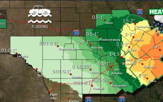
A flood watch has been issued for Austin and the surrounding area, including Bastrop, Caldwell, Fayette, Hays, Travis and Williamson counties, until 9 p.m. Monday.
The National Weather Service says up to three inches of rain is expected Monday, with isolated amounts up to 4-6 inches, which could cause flash flooding.
NWS officials warned that rivers, creeks and other low-lying areas, as well as low water crossings, may be flooded at some point during the day. The Lower Colorado River Authority’s rainfall totals map shows close to 2 inches of rain has fallen in Southeast Austin as of 9 a.m. Other parts of the city are approaching an inch of rain or more.
Wednesday evening, the NWS says, a strong, arctic cold front will move through Central Texas. “This will not be a repeat in severity and impacts of the February 2021 winter storm, however hard freezes are expected, very cold wind chill values, and a potential wintry mix of precipitation is possible Thu morning,” the Weather Service said in a tweet.
Follow the latest updates from the National Weather Service below: