- Southport hosts annual Hurricane Expo ahead of the 2024 season
- How to protect your car before a hailstorm
- ‘We lost everything’: East Texas residents confront their future after flooding
- Here's how to get your flooding debris picked up by the City of Houston
- Mosquito activity on the rise due to rainfall, flooding across Texas
Severe Weather Awareness Week: Tips on how to respond to Houston's weather hazards
With hurricane season and the Houston summer just a few months away, now is a great time to increase your knowledge of severe weather hazards.
HOUSTON — Severe Weather Awareness Week in Texas is March 7-11, and there’s no better time than now to brush up on your weather knowledge, especially with Houston summer and hurricane season just a few months away.
Each day this week will focus on one weather safety topic that we Texans battle with the most:
- Monday – Heat Safety
- Tuesday – Thunderstorm Safety (lightning, hail, and wind)
- Wednesday – Tornado Safety
- Thursday – Flood Safety
- Friday – Beach Safety
The KHOU 11 Weather Team is breaking each one of these elements down in order to prepare you for severe weather.
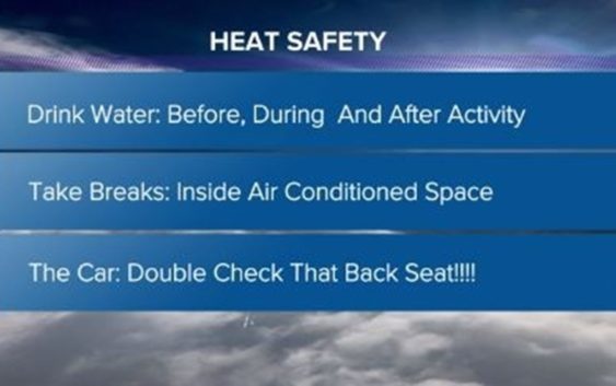
Heat Safety
According to the National Weather Service, heat is the leading cause of weather-related deaths each year in the U.S.
We all know Houston summers can be brutally hot, and the heat becomes especially dangerous if it lingers for more than one day. If you’re not prepared for it, you could become a victim to heat exhaustion or heatstroke.
The CDC warns that high body temperatures from heatstroke can lead to organs shutting down, brain damage or even death.
Tips to protect yourself from the heat
- If you have to be outside during the heat, wear light-colored, loose clothing. Wear a wide-brimmed hat and use sunscreen.
- If you’re working or exercising outside, limit activity to early morning or the evening when it’s cooler. Don’t wait until you are thirsty to seek air conditioning. If you’re not at home, consider visiting malls, movie theaters or libraries.
- Water is the most important weapon against heat. Water is how your body stays cool by creating sweat from the water you drink. It’s very important to stay properly hydrated on a hot Houston summer day.
- Check on your friends, family and neighbors during heat waves.
Thunderstorm Safety
Houston is no stranger to severe weather, but it’s important to know the difference between a Severe Thunderstorm Watch and a Severe Thunderstorm Warning.
- Severe Thunderstorm Watch: A Severe Thunderstorm Watch is issued when severe storms are possible in the near future. It’s important to stay tuned to the local forecast and monitor sky conditions. Know where to take shelter.
- Severe Thunderstorm Warning: A Severe Thunderstorm Warning is issued when a severe storm is happening or is imminent. You’re going to want to take shelter immediately. Check the local forecast for updates as conditions can change rapidly.
Thunderstorms can produce strong winds, lightning, hail storms, and tornadoes.
If you see lightning, try using the “30-30 Rule,” which means after you see lightning, start counting to 30. According to the CDC, if you hear thunder before you reach 30, go indoors. Once you’re indoors, keep listening for the thunder. If you hear the next boom 30 minutes after the first, stay inside.
Tornado Safety
KHOU 11 Chief Meteorologist David Paul said tornadoes are one of nature’s most dangerous and scary phenomena.
The intensity of tornadoes is measured using the Enhanced Fujita (EF) scale.
In Houston and southeast Texas, when we get tornadoes, most often they are the weak tornadoes, EF 0, that come and go quickly, sometimes with little to no warning.
Stronger tornados, like the most intense EF 5, are most often seen in areas like Kansas.
According to the NWS, you need to be aware of three different tornado alerts:
- Tornado Watch: Weather conditions could lead to the formation of severe storms and tornadoes
- Tornado Warning: A tornado has been spotted or indicated by weather radar, meaning a tornado is occurring or expected soon
- Tornado Emergency: An exceedingly rare situation with a severe threat to human life and catastrophic damage due to a confirmed violent tornado
If you’re in your home or business and a tornado is headed to your area, stay inside and head to the first floor. Find an interior closet away from the exterior walls of the home or building.
You want to stay away from walls that have windows or glass doors because broken glass could be the most dangerous part of a tornado.
Flood safety
Flooding is a common experience in the Houston area. It’s important to know if you’re in a flood-prone area and be prepared for flooding before it happens.
If you’re in an area that is experiencing heavy rainfall and you see water rising:
- Get to higher ground
- Do not drive into water
- Stay informed
Since Houston is no stranger to flooding, it’s important to know the difference between a flood watch and a flood warning.
According to the NWS, a flood watch is issued when flooding is possible. It’s important to stay tuned to the local forecast and be ready to seek higher ground if needed.
A flood warning is issued when flooding is happening or will happen soon. If you’re driving along an area of high water, seek higher ground immediately. As always, be sure to remember this rule: Turn around. Don’t drown.
We have seen flooding events devastate Houston communities. The best way you can help your neighbors during a flooding event is:
- Plan an evacuation route before the water gets too high
- If flooding is expected, help others get to elevated areas
- After storms, check on your neighbors and keep others out of floodwaters
Floodwaters can contain chemicals, sewage and disease.
Be careful if you need to walk through floodwaters because there could be debris and sharp objects that can cause injury.