- WATCH: Video Shows Confirmed Tornado touches down in Columbus County
- Residents begin clean up after storms, apparent tornado roll through NC Tuesday
- NC State researchers find increased fecal contamination in coastal waters due to sunny day flooding
- Flooding lingers in Liberty County neighborhoods near Trinity River with more rainfall expected
- North Carolina behind on hurricane preparedness, study shows
Is Tornado Alley shifting east? Weather IQ
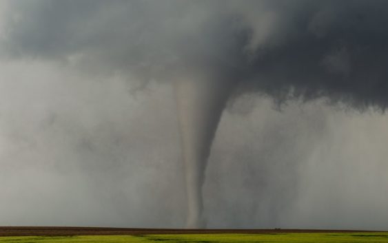
Tornado Alley is known as being the most active place for large and dangerous tornadoes in the central United States, but that could be changing.
CHARLOTTE, N.C. — The United States averages over 1,200 tornadoes every year, with many of those hitting Tornado Alley, the central U.S. states where severe weather strikes more than the rest of the country.
But Tornado Alley could be bigger than you think and may be shifting east.
Is Tornado Alley expanding or shifting east?
Tornadoes can happen any time of year but their frequency increases dramatically during April, May and June. From Texas to South Dakota, this zone is known as Tornado Alley, and it’s infamous for numerous large, long-track tornadoes. However, the number of tornadoes has increased further east, forming a new Tornado Alley that covers a much larger area.
The U.S. receives more tornadoes than any other country due to its weather patterns. Warm moist air from the Gulf of Mexico collides with cold air pushing in from the northwest and warm, dry air from the west. This is a prime setup for widespread severe weather outbreaks.
But this pattern is trending further away from the original Tornado Alley.
The reason why
More evidence is needed to say empirically why this shift is happening, but the National Weather Service did say the increases in radar technology and social media have led to more reported tornadoes as well.
“Now that we are in this new social media-driven world, another 10 years of research and data will help us, more accurately decipher why this trend is happening,” Trisha Palmer with the National Weather Service in Greenville-Spartanburg said.
However, the recent change could be due to changes in the climate. Widespread droughts to the west and southwest appear to have shifted this pattern further east. The Plains are also drier than they once were, which is limiting the number of historic tornadoes seen in the past.
Check out this map:
Since 1979, the amount of favorable tornado days has declined for Texas and part of the original Tornado Alley. Meanwhile, the number of tornado days has shot up east of the Mississippi River.
The ingredients needed to produce long-lived epic tornadoes are flourishing more and more here in the area of red (see graphic above). This includes Arkansas, Mississippi, Alabama and Tennessee. This is the second official Tornado Alley, known as Dixie Alley.
This area is responsible for most of the tornado fatalities since 1950, mainly due to a higher population compared to the central U.S. This area also has more nocturnal tornadoes on record.
There are multiple Tornado Alleys
The Tornado Alley in the middle of America gets all of the recognition and Dixie Alley is up and coming. These two are recognized by the National Weather Service and the Storm Prediction Center. However, there are two more.
These two are unofficial, but have been discussed by both organizations mentioned above. Hoosier Alley around Indiana is ranked as the third-most active area for tornadoes, according to the research from Michael Frates.
Lastly, a smaller area, known as Carolina Alley, was also recognized. The Carolina Alley runs between the Sandhills and Carolina coast.
As we head into the tornado and severe weather seasons, the National Weather Service asks if you see a tornado or any damage, to report it to them.
Contact Chris Mulcahy at cmulcahy@wcnc.com and follow him on Facebook, Twitter and Instagram.