- Houston Emergency Operations Center remains on high alert after multiple rounds of severe weather
- ‘A sense of renewal’: Caddo Mounds historic site reopens 5 years after tornado destroyed property
- Check the latest list of closed streets in downtown Houston from storm damage earlier this month
- The night that one-fifth of the population of a Texas town died in a tornado
- SAWS water main break floods I-35 in San Antonio
Flash flood warning in effect for Wake, Johnston counties as storms roll through, creating dangerous road conditions
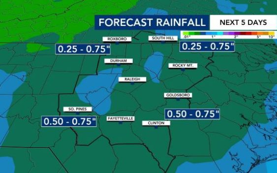
Raleigh, N.C. — Heavy downpours impacted areas from the Triangle to the southeast early Thursday morning and throughout the commute.
A flash flood warning is in effect for Wake and Johnston counties until 10:30 a.m. At 7:30 a.m., heavy downpours were creating dangerous conditions in Raleigh, Cary and Clayton. Crashes and flooding were reported on major roads in the Triangle, and the National Weather Service said 2 inches of rain had already fallen.
The storms moved into our southern counties first, with thunder, lightning and heavy bands of rain. According to WRAL meteorologist Zach Maloch, storms and rain will drift northward, impacting the Triangle for much of the morning.
WRAL News has received multiple reports of flooding and ponding on roads, including on Interstate 440 East near Glenwood Avenue, where a crash closed multiple lanes, and on U.S. Highway 1 near Cary Parkway.
The storms, which will not be severe, will move out of the area by noon.
Thursday afternoon will be partly to mostly cloudy with highs in the upper 60s in Raleigh and warmer to the south.
Friday will be a partly cloudy and dry day with a high of 77 degrees expected in Raleigh — it will be a great time to get outdoors before rain returns after sunset.

According to WRAL meteorologist Zach Maloch, more rain and storms will move in Friday night through Saturday morning along a cold front. Counties from central Wake County to the south and east are under a Level 1 risk for severe weather.
The scattered rain and a few storms will continue Saturday morning, mainly impacting communities southeast of the Triangle.
“The timing of this system will keep the severe risk lower,” Maloch said.
Saturday will be another warm day, with a high of 78 degrees.
Things will stay spring-like for a while. WRAL meteorologist Aimee Wilmoth says there’s no shots of cold air like we saw last weekend on any forecast models. That said, it’s important to remember our average last freeze comes in mid-April.
Our normal high temperature for this time of year is 62 degrees, so the entire week will be warmer than usual.
