- Two people, including a child, dead after Oklahoma tornadoes; governor declares state of emergency
- Build your hurricane season preparedness kits this tax-free weekend
- Residents begin going through the rubble after tornadoes hammer parts of Nebraska and Iowa
- Midwest tornadoes flatten homes in Nebraska suburbs and leave trails of damage in Iowa
- WATCH: Massive tornado caught on camera in Iowa
Panovich: Severe weather possible in the Carolinas Wednesday
Widespread rain and thunderstorms are possible across the Carolinas and Charlotte area Wednesday afternoon and evening. Some could even see tornadoes.
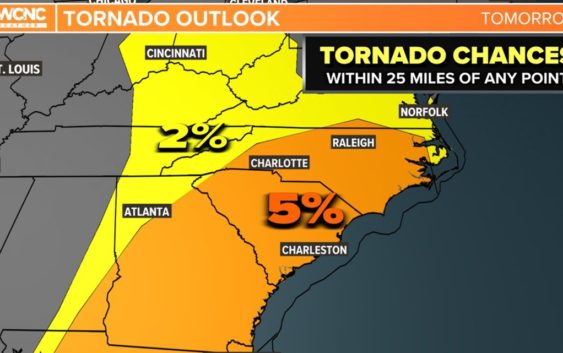
CHARLOTTE, N.C. — A strong storm system that’s produced widespread severe weather and tornadoes in Texas and part of Louisiana and Mississippi is now marching east with the threat of more severe storms in the Carolinas Wednesday.
While there is a chance we see some more stable air in the morning to help the amount of wind shear could be more than enough to overcome even mostly cloudy skies. The main risk for sure will be wind, the biggest questions are about the tornado risk. While the risk appears low, if we see warmer and more humid air move in early in the day watch out!
Wednesday: Carolinas impacted
The threat for severe storms will be lower than areas west of the Carolinas, but there is a low-to-moderate threat for severe storms Wednesday afternoon and evening. This is the best Charlotte for severe weather thus far in 2022.
All areas in North Carolina and South Carolina will be at risk for strong storms, including Charlotte, Concord, Fort Mill, Gastonia, Lincolnton, Monroe, Mooresville, Rock Hill, Salisbury, Statesville, and Waxhaw.
Timing
The window is loosely open from late morning until the early evening. Right now, the best opportunity for severe storms and tornadoes for the Charlotte area will be from noon Wednesday until around 6 p.m.
Tornado threat
A 5% chance is much lower than the 10-15% chance areas out west have had, but it only takes one to make the difference. There will be a lot of wind shear to the atmosphere that allows for storms to rotate. The worst scenario would be isolated rotating thunderstorms (supercells) that are typically stronger and have better chances to produce tornadoes.
Wind threat
The wind threat is at 15%, which means that roughly 1 out of every 6 thunderstorms could produce damaging wind gusts exceeding 58 mph. Regardless of any thunderstorms, this approaching front will drive up the winds.
Winds will be gusting from 20-35 mph for most of the area. These winds will be even higher in the mountains. We can blame the low-level jet on this. This jet stream is about a mile up and it will be blasting some very warm and unstable winds aloft. This will also add that twist to the atmosphere mentioned above.
Flooding Threat
This threat diminishes compared to the threats over the last couple of days, but these strong thunderstorms could produce a lot of rain that would lead to some localized and urban flooding. Up to 2 inches of rain is possible for some locations in the Charlotte area.