- Mosquito activity on the rise due to rainfall, flooding across Texas
- Volunteers help Conroe community clean up in wake of flooding in Montgomery County
- Why leaders are urging NC residents to start hurricane prep now
- Storms could produce hail, damaging winds south of Charlotte
- Large hail and strong winds cause damage in San Marcos and the Hill Country
Union, Chesterfield counties under tornado watch until 8 p.m.
Charlotte will likely see heavy rain and thunderstorms, with the threat of damaging winds and severe weather Thursday.
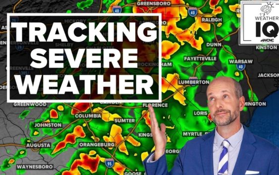
CHARLOTTE, N.C. — As a line of storms moves through the Carolinas on Thursday, parts of the Charlotte area have seen plenty of rain and the threat of severe weather.
Most recently, Union County in North Carolina and Chesterfield County in South Carolina were both placed under a tornado watch until 8 p.m. The cities of Indian Trail, Monroe, Trinity, and Weddington are included in the watch in Union County, while Chesterfield is included in Chesterfield County.
Additionally, Mecklenburg County is under a Flood Advisory until 4 p.m.
A tornado warning for both Chester and York counties in South Carolina was activated at 12:05 p.m. by the National Weather Service. The warning, which expired by 12:30 p.m., came as the Charlotte area was predicted to face severe weather in the afternoon as a line of storms moves across the Carolinas. Eventually, the NWS removed York County from the warning before 12:30 p.m., but Chester County remained until that time.
WCNC Charlotte chief meteorologist Brad Panovich said the first wave of rain, which started around 8 a.m., was mostly light to moderate rain. The threat of strong storms is more within the afternoon when the back edge moves through during the warmest point of the day.
Panovich said the severe weather outlook appears to show the mountains and foothills being mostly out of the woods for severe weather. Areas along Interstate 77 will likely be the dividing line for where the storms really get cranking.
“From Charlotte east, this is the area we’ll watch this afternoon,” Panovich said.
Areas at risk for severe weather Thursday include Albemarle, Charlotte, Concord, Gastonia, Hickory, Huntersville, Lincolnton, Monroe, Mooresville, Salisbury, Shelby, Statesville, Taylorsville and Waxhaw in North Carolina. South Carolina cities and towns in the medium risk include Chester, Fort Mill, Indian Land, Lancaster, Rock Hill and York.
Damaging winds the biggest threat
Rain moved in by 8 a.m. and those showers will last through midday. Panovich said the afternoon could see stronger storms with a primary threat of damaging winds. Thursday will be extremely windy, with gusts up to 40 mph possible during the storms.
“Our primary threat is still damaging straight-line winds,” Panovich said. “Overall, the wind risk is obviously, by far, the highest of all.”
The wind toppled a tree onto power lines along Providence Road in south Charlotte Thursday morning. At one point, hundreds of Duke Energy customers were without power. Crews were able to quickly restore power but the road was blocked until just before 9 a.m.
In a house
When at home, you and your family need to go to their safe place. First, go to the lowest level of your home immediately. A basement is ideal, but if you don’t have one, find the most interior room of your house away from windows.
Crouch on the floor and cover your head as much as you can. Brad Panovich’s family keeps helmets in their safe space, along with other supplies for a tornado warning.
Your safe place should have a flashlight, as well as food and water. You should always wear shoes because if there is damage, you may have to walk through nails or broken glass.
In an apartment
In an apartment building, the same rules apply. You need to head to the lowest level, but use the stairs because the elevator could lose power. A place like under the staircase, an interior hallway or a room with no windows is your safe place. Crouch and cover your head.
But what about your car? This is the riskiest place to be during a tornado. If the tornado is far enough away you can drive away from it in 90-degree angles until you find a safe place. If it is nearby, DO NOT try to outrun it. Instead, pull over. Keep your seatbelt on and duck below the winds and cover your head.
An EF1 tornado can push a car and an EF2 can lift it off the road. DO NOT seek shelter under a bridge or overpass. Flying debris tends to move even faster, making it more dangerous.
At work or shopping
Most importantly, don’t panic. Be mindful of others and move as quickly and safely as possible to an interior bathroom or storage room. Any enclosed place away from windows is your target. Some establishments will have a marked tornado shelter.
Out in the open
If you are out in the open, and there is no nearby shelter, find the lowest-lying area away from trees and anything that could produce debris. Lay flat on the ground and put your hands behind your head.
Theater or Church
If a tornado warning sounds while you are in church or the theater, you’ll want to find the lowest interior room without windows. But if there is no time. Hide under the pews or seats.
Mobile Home
In a mobile home, get out and run to a tornado shelter nearby. A mobile home historically is the worst place to be in the path of a tornado. Tornado fatalities are more common for those who live in mobile homes since they do not have the foundation that a home has.
The timing
Panovich said the best timeframe for severe weather will likely be from around noon to 2 p.m. By 4 p.m., the trailing edge of storms will be moving through with a threat of strong storms. Eastern North Carolina could see some supercells by 7 p.m. and into Thursday night.
“If it’s going to happen, it’s going to happen this afternoon as the front pushes off the east,” Panovich said.
Panovich said the convective available potential energy — known as CAPE, or “thunderstorm fuel” — will build up in the middle of the day.
“You can see it does build a little towards the middle of the day,” Panovich explained. “And so, at 3 o’clock, there is some energy. This is that thunderstorm fuel, there is some energy there for these storms to get a little stronger as we go into the afternoon hours.”
Other threats
Wind: The No. 1 threat would be severe thunderstorms with gusty winds. These winds could occasionally gust over 50-60 mph, causing spotty damage and downed trees.
Tornado: There will be some spin to the atmosphere and there is a chance for a spin-up tornado but the treats are very low at this time. The Storm Prediction Center has a 2% chance for tornadoes in the areas north and south we mentioned previously in the article (in orange).
Hail: Currently this threat is the lowest severe parameter for the area.
Flooding: Any thunderstorm system has a chance to bring some localized and urban flooding, so the threat is there but most rain totals will range from a half-inch to 1.5 inches. This will all come within a six-hour period, which will lead to some significant ponding in areas. It wouldn’t be unheard of to see some isolated reports of 2 inches of rain, especially in the North Carolina mountains.