- Rock Hill storm damage costs are 'somewhere around $5 million.' That number doesn't include damage to personal property
- Rock Hill storm damage costs are 'somewhere around $5 million.' That number doesn't include damage to personal property
- ‘Somewhere around $5 million’ | Rock Hill officials see major storm damage costs
- The deadliest tornadoes to ever hit Austin
- Whiteville resident recalls events from Tuesday nights tornado
First Alert Weather Day: severe weather threat moving in
NORTH TEXAS (CBSDFW.COM) – The First Alert Weather Team has issued a First Alert Weather Day for May 24 starting at 11:00 a.m.
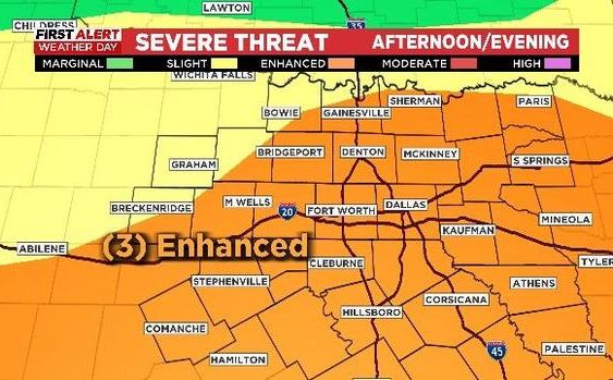
The National Weather Service (NWS) Storm Prediction Center has issued an enhanced storm risk for later today and this evening.
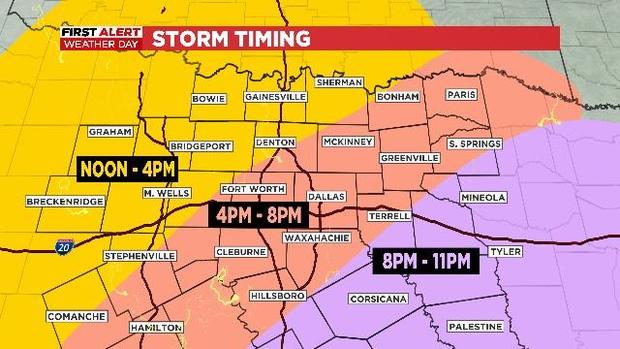
Strong and/or severe storms are expected to start this afternoon in counties to the northwest. Damaging winds are the primary concerns but it includes a slight tornado risk. Here is the expected timing of the storms as they progress across the Metroplex at the end of the day and into the evening.
Hail from these storms is the major threat in the western counties. Otherwise, 60 mph+ winds with these storms are expected along with the above mentioned tornado threat and a Flash Flood risk.

From September 1, 2021 to today (basically: Fall-Winter-Spring), North Texas has registered the 3rd driest run of weather over the last 50 years. In short, it has been very dry since last Fall. This could be a huge rain for the Metroplex over the next couple of days.
The NWS has posted a Flood Watch for the SE counties though Wednesday night; I would not be surprised to see this watch expanded later this afternoon.
The Global High-Resolution Atmospheric Forecasting System (GRAF) forecast model shows breathtaking rainfall amounts inside the Metroplex. If this verifies we could witness extensive urban flooding. But rainfall potential forecast modeling is very hit and miss, so there are no guarantees. The information does however suggest that there is a significant flooding risk over the next 36 hours and that the storms moving in will have to be carefully monitored.
Hang in there, all the unsettled weather is gone for the 3-day holiday ahead and the month of May will end like it’s mostly been — HOT!