- WATCH: Video Shows Confirmed Tornado touches down in Columbus County
- Residents begin clean up after storms, apparent tornado roll through NC Tuesday
- NC State researchers find increased fecal contamination in coastal waters due to sunny day flooding
- Flooding lingers in Liberty County neighborhoods near Trinity River with more rainfall expected
- North Carolina behind on hurricane preparedness, study shows
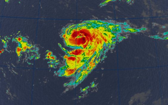
Tropical Storm Danielle forms in the north Atlantic
There are two other areas in the tropics being watched by the National Hurricane Center, but none of them pose any threat to landmasses at this time.
COLUMBIA, S.C. — Tropical Depression Five formed in the north Atlantic early Thursday morning and became Tropical Storm Danielle by the late morning hours. It is forecast to become our first hurricane of the 2022 season this week. There are two other areas in the tropics being watched by the National Hurricane Center, but none of them pose any threat to landmasses at this time.
Tropical Storm Danielle is located in the north Atlantic. It is moving slowly towards the east at about 2 mph. The storm is expected to meander in the north Atlantic over the next couple of days.
Danielle has maximum sustained winds near 40 mph with some higher gusts. It is expected to strengthen and become a hurricane, but no landmasses are in jeopardy.
Another area in the Atlantic being watched is located several hundred miles east of the Leeward Islands. Environmental conditions remain only marginally conducive for development, buy any additional strengthening of the system over the next few days could lead to the formation of a tropical depression.
The disturbance is forecast to move slowly west-northwest, toward the adjacent waters of the northern Leeward Islands. The NHC gives this area an 80% chance of further development over the next five days.
The last area of concern is an area of low pressure located over and to the north of the Cabo Verde Islands. While surface observations indicate pressures are low in this area, the associated shower activity is currently poorly organized.
There is still a potential for the system to become a short-lived tropical depression within the next day or so before environmental conditions become unfavorable for further development. The NHC gives this area a 40% chance of further development over the next five days.