- Mosquito activity on the rise due to rainfall, flooding across Texas
- Volunteers help Conroe community clean up in wake of flooding in Montgomery County
- Why leaders are urging NC residents to start hurricane prep now
- Storms could produce hail, damaging winds south of Charlotte
- Large hail and strong winds cause damage in San Marcos and the Hill Country
Hurricane Ian continues to strengthen; impacts expected to Cape Fear late this week
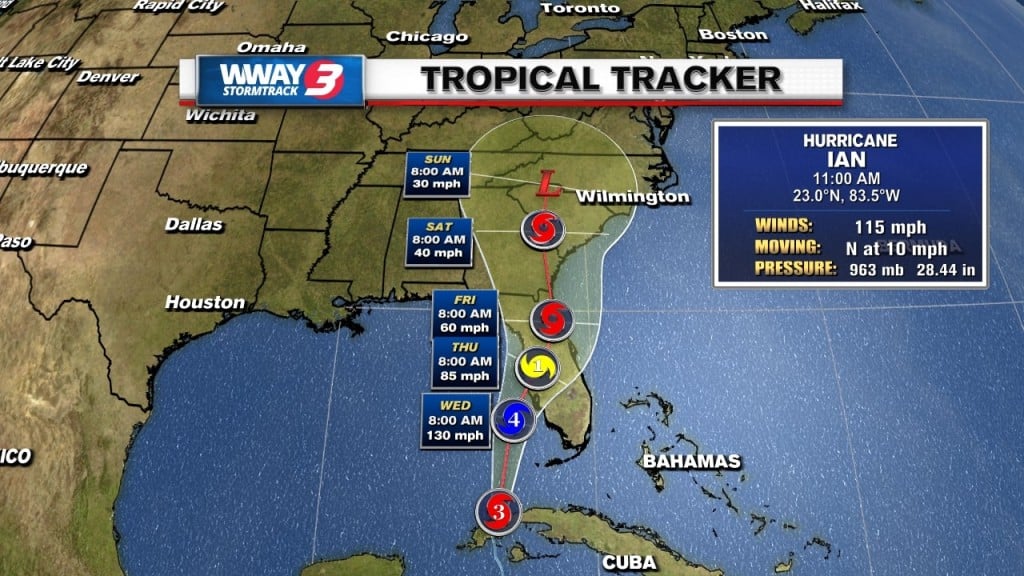
WILMINGTON, NC (WWAY) — Hurricane Ian is continuing to intensify as it approaches the Florida coast.
As of 11:00 am, Ian is a major category 3 hurricane. The storm is expected to reach category 4 status later today as it pushes towards the Sunshine State.
Hurricane Warnings and Tropical Storm Warnings line the entire west coast of Florida.
Landfall is expected late Wednesday into early Thursday, with massive storm surge and multiple feet of rainfall.
The path of the Ian is still uncertain beyond landfall. Most models have the storm tracking over land up through Georgia, South Carolina and Central North Carolina into the weekend. A few models carry Ian across Florida and briefly back into the Atlantic before making another landfall in Georgia/South Carolina.
Regardless of track, impacts to the Cape Fear look to be the same.
Rain is expected to begin early Friday morning, picking up in intensity and coverage as the day goes on. The rain will last on and off into Sunday.
Up to 6″+ is expected, with flooding possible in some locations. Winds aren’t expected to be a major concern, but gusty squalls are still likely, with a few isolated, spin-up tornadoes also being possible.
The rip current risk and wave-action along the coast will go up as we get closer to the weekend.
Keep it tuned to the StormTrack 3 Weather team for the very latest on Ian.