- WATCH: Video Shows Confirmed Tornado touches down in Columbus County
- Residents begin clean up after storms, apparent tornado roll through NC Tuesday
- NC State researchers find increased fecal contamination in coastal waters due to sunny day flooding
- Flooding lingers in Liberty County neighborhoods near Trinity River with more rainfall expected
- North Carolina behind on hurricane preparedness, study shows
Hurricane Ian, now Cat. 3, makes landfall in Cuba; expected to impact Florida, NC
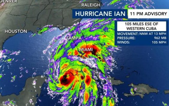
RALEIGH, N.C. — Hurricane Ian on Tuesday made landfall in Cuba as a major Category 3 storm.
Central and eastern North Carolina are bracing for possibly detrimental impacts from Hurricane Ian late this week.

Ian was upgraded to a major hurricane early Tuesday morning with winds at 115 mph. Cuba was already seeing rain impacts from the storm.
Ian will strengthen into a Category 4 storm on Wednesday before weakening due to drier air. A second landfall is expected for Florida near Tampa late Wednesday or Thursday, possibility as a Category 2 or 3 storm.
Ian is approaching the Florida Keys and rapidly intensifying in warm Atlantic waters.
Hurricane Ian will run into drier air and weaken into a tropical depression as it moves along Florida’s coast into Georgia, and N.C. could feel impacts as soon as Friday.
Hurricane Ian impacts expected in NC

The Triangle and communities to the east could experience pockets of heavy rain, with up to 4 inches possible, gusty winds and isolated tornadoes all during day on Saturday with rain lingering into Sunday.
Winds will gust up to 30 mph, but they won’t be high enough to be damaging, Gardner said. The main impact will be heavy rain.
There will be wind and rain in the mountains, but the weather won’t be severe there, Gardner said.
The Carolina coast could see 40 mph gusts and 4-6″ rain in spots.
NC prepares for Ian’s impacts

Sunday night, hardware stores across the Triangle were fully stocked ahead of Hurricane Ian. Some of the most popular items that go quickly when any storms threaten include batteries, flashlights and extension cords.
If you’re thinking about grabbing some of those items, store managers, including those at Burke Brothers Hardware in Raleigh, said it isn’t too early.
Officials in Raleigh are keeping a cautious eye on Hurricane Ian as it charges toward Cuba and Florida.
Stormwater crews were ramping up efforts Monday to reduce the impacts of Hurricane Ian throughout the city.
They started lowering lake levels at Lake Johnson in anticipation of heavy rainfall.
Crews told WRAL News if they don’t control water levels at Lake Johnson, all that water rushes downstream and hits flood-prone areas like Rose Lane.
Heavy rain and whipping winds from major storms have resulted in fierce flooding in parts of the city like Rose Lane where Walnut Creek flows through.
“What we’re trying to do is lower the lake levels to try to capture as much rainfall runoff as we can to try to help prevent flooding downstream,” said Kelly Daniel, the flood early warning system project manager for the city of Raleigh.
Daniel said it’s a proactive measure to keep residents in those flood-prone areas safe.
Officials said if you are in the vicinity of flood plains keep an eye on the forecasts and never drive through a flooded area.
Residents like Physiwell Maume said they were thankful to see proactive measures put in place ahead of Ian’s impact.
“I appreciate it because the last thing we want is floods that destroy a lot of things and lives too,” said Maume. “I think if we can prevent that it’s a good thing.”
Another area of concern with any possible weather event is power outages.
Duke Energy said that before it sends crews to help Florida, is has to make sure there are enough crews to help North Carolina in case the situation worsens. Duke Energy said it expects to have a better idea of storm impacts in North Carolina over the next few days.

Meanwhile, the Red Cross is often among the first to respond after storms roll through an area.
“We have two concerns: supporting our team on tour in the north Florida gulf coast area where the storm may indeed impact. So we prepare and send some qualified individuals there,” said Barry Porter with the American Red Cross, Eastern NC Region. “At the same time, we’re doing hold-downs and evaluating where our own people are so if something does happen in the Carolinas we can also respond.”
Porter said the most important thing is to find and seek safe shelter, have a supply kit ready to go and to be weather weary after the event.