- The deadliest tornadoes to ever hit Austin
- Whiteville resident recalls events from Tuesday nights tornado
- Tornado damage reported in southern NC after Tuesday's severe storms
- If your home floods, here are steps you can take to address mold
- WATCH: Video Shows Confirmed Tornado touches down in Columbus County
Tornado watch canceled for Charlotte area as Nicole moves over Carolinas
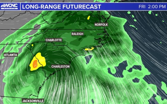
Nicole brought heavy rain to the Carolinas, with flooding reported in the North Carolina mountains. A tornado watch for the Charlotte area was canceled Friday.
CHARLOTTE, N.C. — A tornado watch for Mecklenburg County and areas east of Charlotte was canceled around 2 p.m. Friday, the National Weather Service announced.
The watch was issued early Friday morning as the remnants of Nicole moved over the Carolinas with heavy rain and gusty winds. Multiple tornado warnings were issued in eastern North Carolina.
WCNC Charlotte chief meteorologist Brad Panovich was tracking a particular line of storms associated with Nicole that resulted in tornado warnings in Virginia and the Carolinas. Fortunately, the threat for severe weather in the form of a tornado is pretty much gone now.
A tornado watch means conditions are favorable for tornadic development. It does not mean a tornado has been spotted on the ground or detected by radar.
Despite the lack of tornadoes, there is still a significant flooding risk in western North Carolina. Some areas in the mountains and foothills saw over 8 inches of rain during Nicole. The highest total was at Mount Mitchell, where 8.4 inches was reported just after noon on Friday.
Grandfather Mountain reported 7 inches of rain and Old Fort reported 5.8 inches. Panovich and meteorologist Brittany Van Voorhees said the rain rates would lead to a flooding risk in the mountains, as the storm was moving quickly over the region.
Friday is a Weather Aware day for the Charlotte region due to Nicole’s impacts. That label means you should be aware of any potential weather that could impact your personal safety, your family’s safety and protecting any property.
Heavy rain is also leading to isolated flooding. Heavy rain may cause streams to rise quickly, and a Flash Flood Warning is in place for portions of Caldwell, Burke, and Avery counties. This means flash flooding is already happening or could happen at any point due to additional rainfall.
Reports of flooding have already happened toward the mountains and foothills due to this risk. Please remember to turn around, don’t drown and never drive through flooded roadways or around barricades.
A flood watch is in effect for several counties in the North Carolina mountains and foothills. A flood watch is in effect until 1 a.m. Saturday for Ashe, Avery, Burke, Caldwell and Watauga counties in North Carolina. Some areas in the mountains could see up to 4 inches of rain. This includes the cities and towns of Blowing Rock, Boone, Lenoir, Morganton and Newland. With the rain falling over a short period of time, this increases the risk of flooding.
The first waves of rain moved into Charlotte Thursday night. Anyone who watched the Panthers defeat the Falcons on Thursday Night Football saw it, with sheets of rain falling at times during the game with gusty winds. Conditions only worsened overnight, with more rain and wind across the entire WCNC Charlotte viewing area.
Nicole timing
“That Friday morning time frame, to me, is going to be the worst of this,” Brad Panovich said. “And as we get into Friday evening, things should start to improve pretty dramatically.”
Overnight tornadoes can pose a particularly dangerous situation because people are asleep. Before you go to bed Thursday night, be sure to have at least two ways to be awoken by severe weather alerts.
RELATED: Weather IQ: Finding your safe place
Panovich said during the day Friday, the mountains will get hit with heavy rain. A persistent flow of warm, humid air will bank against the mountains with a risk of flash flooding across the North Carolina High Country.
The Charlotte metro could see wind gusts up to 35 mph, with stronger winds expected east of the Queen City. Sustained winds will be much weaker in the Charlotte metro area, Panovich said.
Wind gusts could knock down trees limbs and powerlines causing scattered electrical outages.
Nicole rainfall projections
- NC mountains: 2-4 inches
- Charlotte metro: 1-2 inches
Panovich said there could be flash flooding because the rain will be heavy over a short period of time.
Wake Up Charlotte To Go is a daily news and weather podcast you can listen to so you can start your day with the team at Wake Up Charlotte.
SUBSCRIBE: Apple Podcasts || Spotify || Stitcher || TuneIn || Google Podcasts
All of WCNC Charlotte’s podcasts are free and available for both streaming and download. You can listen now on Android, iPhone, Amazon, and other internet-connected devices. Join us from North Carolina, South Carolina, or on the go anywhere.