- Here's how to get your flooding debris picked up by the City of Houston
- Mosquito activity on the rise due to rainfall, flooding across Texas
- Volunteers help Conroe community clean up in wake of flooding in Montgomery County
- Why leaders are urging NC residents to start hurricane prep now
- Storms could produce hail, damaging winds south of Charlotte
NASA hurricane-tracking satellite falls out of contact with Earth
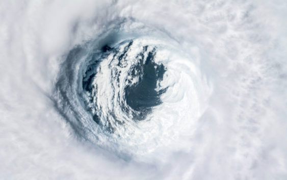
NASA scientists are attempting to reestablish contact with a satellite that serves as part of an agency array tracking the formation and movement of hurricanes in the Earth’s oceans, Space.com’s Robert Lea reported Thursday.
The Cyclone Global Navigation Satellite System (CYGNSS) is billed as the “first space-based system to collect frequent measurements of wind speeds from the ocean’s surface” and is tasked with tracking activity near the eyes of forming cyclones, typhoons and hurricanes. The system is comprised of eight separate spacecraft that in aggregate form a picture of maritime storm behavior around the world used by scientists to project and measure severe weather activity.
This network has been compromised in part over the last several weeks after one of its crafts, designated “FM06,” stopped communicating measurements in late November. The system continues to operate without the unit’s participation but will have a lower valence of coverage without the missing piece of the network, according to the agency.
“If the team isn’t able to reestablish contact, the FM06 satellite would primarily affect the constellation’s spatial coverage,” NASA said in a statement released on Dec. 9. “However, the CYGNSS constellation could continue to meet its scientific requirements and objectives.”
The unique system began development at the University of Michigan in 2012 on the back of a $152 million investment from NASA and was launched into orbit in 2016. The mission achieved its primary research goals by 2019 and has since been operating in an extended mission status, according to Lea. The tools at its disposal include low-frequency GPS microwaves capable of penetrating thick cloud cover and measuring wind speeds close to the water surface near major maritime storms, allowing scientists to get a more accurate picture of the speed and severity of large systems.
Hurricane season in Texas in 2022 was uncharacteristically uneventful, while large named storms such as Hurricane Ian ravaged significant portions of Florida’s Gulf-facing western coast.
More Space