- Here's how to get your flooding debris picked up by the City of Houston
- Mosquito activity on the rise due to rainfall, flooding across Texas
- Volunteers help Conroe community clean up in wake of flooding in Montgomery County
- Why leaders are urging NC residents to start hurricane prep now
- Storms could produce hail, damaging winds south of Charlotte
Tornado Watch issued north of Austin ahead of widespread storms Wednesday night
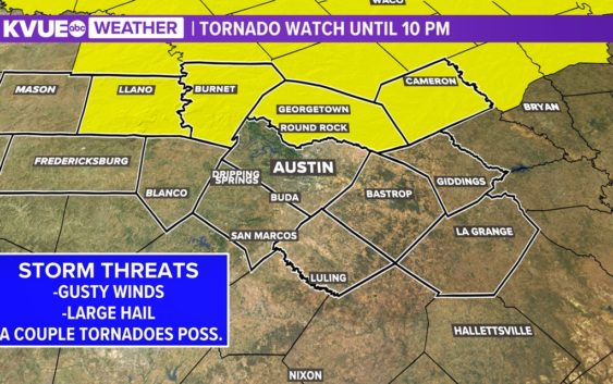
Here’s the latest on the severe threat and timing.
AUSTIN, Texas — Round 1 of severe weather ended Tuesday evening, but we could still have 2 additional rounds of storms between now and the end of the week. The most widespread round of storms will be Wednesday night into Thursday morning as a cold front moves through Central Texas.
For round 2, we won’t be fighting a cap, and again some of these storms could be strong. The Storm Prediction Center includes much of the KVUE viewing area in the “slight” – level 2 of 5 – severe weather risk, with northeastern Milam County now in the “enhanced” – level 3 out of 5 – risk for severe weather.
Some storms will have a chance to pop up briefly in the afternoon between 1-4pm, with is a small increased risk of rotation with the isolated storms that do organize.
Ahead of the front, we could see a few storms develop in the evening which could contain an isolated tornado threat. However, our highest storm chances arrive later in the evening. Later Wednesday night, high-resolution forecast models are hinting at the potential for a strong line of storms pushing through Central Texas Wednesday overnight into Thursday morning. This line would continue to push toward the Coastal Plains through the early morning hours. Some lingering showers will be possible in the Coastal Plains during the morning, but conditions clear later in the afternoon.
Isolated storms possible ahead of the front could develop in the Hill Country around 9:30 p.m.
As the cold front approaches Central Texas, a line of stronger storms could develop closer to midnight, and possibly be in the Austin metro by around 1 a.m.
By 4 a.m, the bulk of moisture is expected to be shifting east, and eventually clearing out of Central Texas come the early afternoon. These lasting storms could remain strong, with the main threats of wind and hail continuing.
Between now and Thursday morning, areas along and east of I-35 could pick up 1 to 2+ inches of rainfall. Some localized totals could be in the 2 to 3 inches range, so we can’t rule out some minor flooding.
The third and final chance for storms this week will be Friday evening as a second cold front moves through. Forecast models are now hinting at some of the storms associated with this system being on the stronger side. The Storm Prediction Center has placed a majority of Central Texas under the “slight” risk for Friday night into Saturday morning. We’ll have additional details on the possible impacts of this system soon.
The KVUE Storm Team will continue to closely monitor this developing forecast.
In the meantime, the extended forecast can be found below: