- Rock Hill storm damage costs are 'somewhere around $5 million.' That number doesn't include damage to personal property
- Rock Hill storm damage costs are 'somewhere around $5 million.' That number doesn't include damage to personal property
- ‘Somewhere around $5 million’ | Rock Hill officials see major storm damage costs
- The deadliest tornadoes to ever hit Austin
- Whiteville resident recalls events from Tuesday nights tornado
Three Tropical Storms Formed; Two More are Coming
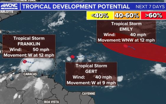
Emily, Franklin and Gert formed over the weekend. But Harold and Idalia don’t have to wait long on deck.
MIAMI, Florida — Roughly 79% of tropical storms and 85% of hurricanes form during these three months: August, September and October. The tropics are heating up right on time, with three tropical storms forming through the third weekend of August.
Active Named Storms
Tropical Storm Emily (One of the weaker Emily’s):
Emily has had a history when ever it pops up but not this year.
Click to learn how infamous Emily has been in the past: Hurricane Emily: The storm that refuses to be retired
Tropical Storm Emily will be just a fish storm. It is turning north in the Atlantic and will hit some unfavorable conditions becoming a tropical depression before fizzling out in the mid Atlantic.
Tropical Storm Franklin (The biggest threat):
This storm is going to be a problem for flooding in the Dominican Republic. Right now rainfall estimates bring 6-12″+ of intense rain meaning dangerous Flash Flooding is going to be possible. Life threatening flash flooding is being warned with this storm so thoughts and prayers to those who can’t evacuate.
After landfall it will soak up some energy undisturbed from some warm prime Atlantic waters and become a hurricane by or before the weekend.
Tropical Depression Gert (Goodbye Gert):
Tropical Storm Gert was short lived and is now down to a tropical depression. Sustained winds dropped to 35 mph and Gert will be just a remanence storm, meaning it only will be a named storm for just over 24 hours.
Names Next Up – Active Systems Soon to Be Named
There are two waves being monitored that are very close to becoming a tropical depression or tropical storm. Before a storm is named and is showing signs of becoming a closed circulation it will gain the name Invest followed by a number and letter. The numbers range from 90-99 and either an L (for Atlantic) or E (for Eastern Pacific). Once Invest 99L is reached, it starts back to 90L.
Tropical Storm Gert was short lived and is now down to a tropical depression. Sustained winds dropped to 35 mph and Gert will be just a remanence storm, meaning it only will be a named storm for just over 24 hours.
Invest 91L (Texas/Mexico landfall this week):
This storm will continue to push east and make landfall in Southern Texas. Right now the intensity does not to be an issue but could be a decent rain maker for parts of Mexico and Texas. The forecast has this becoming a tropical storm her in the next day or two and then dropping back to tropical depression status before landfall but a lot can change. No storms have made landfall in the United States so far, so this is the first chance.
Invest 92L (Hurricane potential but no major threat):
This wave is well east just off the Africa coast and has the best chance to become our 9th named storm (Idalia). No other letter has been retired more than I names but it looks like if this becomes Idalia, it could become our second hurricane of the 2023 Atlantic Hurricane Season but will turn back out into the Atlantic posing no threat to land.