- Carolina Beach is warning of potential King Tide flooding
- NCDEQ launches Hurricane Helene recovery grants program
- Why no hurricanes made landfall in the US in 2025
- Florence to begin interviewing police chief finalists in January
- A West Texas county wants to better prepare for floods. Paying for it will be tricky.
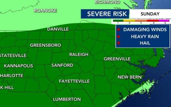
Level 1 severe weather risk Sunday, with potential for heavy rain, hail, & damaging winds
After a warm few days, we are in for cooler temps and storms Sunday.
Much of the state is under a level 1 (out of 5) severe risk for storms, which bring potential for heavy rain, hail and damaging winds.
Futurecast shows storms beginning to pop up around the state starting in the afternoon – starting around 4 p.m. and impacting the Triangle area through around 11 p.m. and possibly continuing overnight.
Our 7-day forecast shows a chance of rain and storms for the next six days. During that time, we could see up to 1.5 inches of rain in some places.
Next week will be much cooler with temperatures in the 80s.

Ideas to beat the heat
If you’re trying to avoid racking up your utility bill, we’ve got some tips to help you beat the summer heat without breaking the bank.

Florida is under a state of emergency as a storm with potential to become a hurricane takes aim at its coastline – and North Carolina could get caught up in the mix.
Tropical Depression 10 formed near the Yucatan Peninsula on Saturday, and is projected to become a category 1 hurricane with winds up to 90mph before making landfall on the Florida coast.
The storm is expected to strengthen into a tropical storm sometime on Sunday and hit Florida by Tuesday and into Wednesday.
North Carolina is also currently in the forecast cone, with the latest track showing a tropical storm moving across NC late Wednesday and into Thursday with wind speeds still around 40 to 50 mph.
Much of the south could be impacted by the heavy rain and gusty winds associated with this storm as it moves northward from Florida.
Franklin could bring dangerous rip currents to NC
According to WRAL meteorologist Aimee Wilmoth, Franklin could become a hurricane over the weekend, possibly as strong as a Category 2.
“By the time we get to Monday, what you need to know about this is it’s going to stay well offshore,” Wilmoth said. “But we could have some indirect impacts along the North Carolina coast late this weekend and early in the week — dangerous rip currents, rough surf and perhaps some beach erosion as well.”
Still, Franklin should stay well off the North Carolina coast.
2nd system could impact Labor Day weekend
Another system formed around the Yucatan Peninsula, becoming Tropical Depression 10.
The formation of the storm prompted a state of emergency declaration from Florida Governor Ron DeSantis.
“It’s likely going to develop in the Gulf of Mexico and could become a tropical depression or a tropical storm,” Wilmoth said. “It’s likely that it does get a name and becomes a tropical storm along the western coast of Florida by the middle part of next week, and then it could impact the North Carolina coast by the end of next week leading into the Labor Day weekend.
The forecasted track of the storm will take it to the Carolinas.
The system likely wouldn’t become a hurricane, Wilmoth said, but there’s enough wind sheer that it could keep the system down to a depression or a tropical storm.
“Nonetheless, the North Carolina coast could certainly feel some impacts by the time we get to the middle and end of next week,” Wilmoth said.
Next Tuesday afternoon, Futurecast shows the system west of Florida, but it will continue racing to the north and east. By Wednesday the system will likely impact Florida before moving into the Atlantic late Wednesday into Thursday, impacting the North Carolina coast through the day on Thursday.
“We’ll let you know if the timing changes, but right now, it looks like the North Carolina impacts will be felt late Wednesday, continuing through the day on Thursday,” Wilmoth said.

The National Oceanic and Atmospheric Administration said above average temperatures in the Atlantic Ocean and the late arrival of El Nino will make for a nastier second half of hurricane season.
With the Atlantic hurricane season already well above normal so far, NOAA increased how many storms to expect and how busy the season can get. The agency said there’s a 60% chance for an above normal hurricane season — twice the agency’s May forecast, which said it was 30%.
The Atlantic hurricane season runs from June 1 to Nov. 30. The most active time is usually September through November, but it’s possible to see a hurricane make landfall any time of the year.