- WATCH: Video Shows Confirmed Tornado touches down in Columbus County
- Residents begin clean up after storms, apparent tornado roll through NC Tuesday
- Flooding lingers in Liberty County neighborhoods near Trinity River with more rainfall expected
- North Carolina behind on hurricane preparedness, study shows
- North Carolina way behind on hurricane preparedness, study shows
What Hurricane' Lee's forecast means for the Carolinas | Brad Panovich explains
The storm, forecast to quickly become a major hurricane, is producing a lot of forecast data. Chief Meteorologist Brad Panovich explains the scenarios.
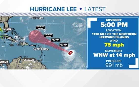
CHARLOTTE, N.C. — Lee has become a hurricane in the Atlantic Ocean, the National Hurricane Center confirmed late Wednesday afternoon.
Lee became a tropical depression Tuesday before being upgraded to a tropical storm hours later. The storm, which officially became a hurricane at 5 p.m. Wednesday is forecast to soon grow into a “major hurricane” with winds greater than 110 mph.
“I want everyone to keep paying attention to it, but no, you should not be worried or freaking out about anything yet,” WCNC Charlotte Chief Meteorologist Brad Panovich explained Wednesday. “It’s still so far out and still uncertain at those time ranges.”
Spaghetti models
The storm’s projected path has garnered attention because of the possibility it could impact the East Coast of the United States. As Panovich explained Wednesday, even with the complete spaghetti model data, it is still too early to know where the storm will go.
“There is currently no long-range guidance that brings it to the East Coast,” Panovich said in a forecast analysis video posted to the Weather IQ YouTube channel. “That doesn’t mean it’s not going to impact the East Coast. It’s too far out to know that.”
Panovich projects it’ll be next week before there is enough long-term data to forecast potential U.S. impacts with any certainty.
Forecast strength
Most data indicates Lee will become at least a Category 4 hurricane with winds of at least 130 mph. Once any storm becomes a Category 3 hurricane with winds of at least 111 mph, the National Weather Service considers it a “major hurricane.”
Some computer models suggest Lee could strengthen to include winds of 150 mph, which would put it dangerously close to the 157 mph winds needed for a Category 5 storm.
Like spaghetti models that predict a storm’s path, there are also intensity models that predict a storm’s strength.
Social media rumors
With the storm still more than 2,000 miles from any portion of the continental U.S., there is still a lot of time for speculation and rumors.
Panovich responded Wednesday to rumors posted to social media about the storm. Panovich, who has been forecasting weather in the Carolinas since 2003, disputes any claims – this early on – that the storm is going to make landfall in any particular place.
“So watch where and who you get information from about this storm,” he said. “There is more misinformation on this one.”
Key factors to watch
Hurricane Lee’s projected forecast path scenarios
Forecasting a hurricane’s path is complicated. For Lee, one of the biggest questions to answer is, “When will the storm begin to turn north?”
Driven by a powerful high pressure system over the Atlantic Ocean and a dip in the jet stream over the United States, Lee will eventually turn north.
Panovich outlines three main scenarios:
- A turn sooner makes the risk greater for Bermuda but lesser for the United States.
- A turn later means a greater for North Carolina, South Carolina, and the U.S. coastline.
- A just-as-likely scenario means the storm could move safely between Bermuda and the United States with minimal impacts on land.
Even that latter scenario, Panovich said, is “splitting the uprights and too dang close [for comfort].”
What’s next
Satellite images are already showing the system looking more organized. The area of low pressure is located halfway between Africa and the Windward Islands.
Model runs, which are published numerous times a day, will soon have clearer visibility into when that northward turn could happen. Even when that begins to appear in the computer models, such a turn would still be days away from happening.
“Big storms are like big ships, they don’t turn on a dime,” Panovich explained. “The sooner you start to see this storm drifting north and making that turn, the better. We don’t want it to wait to the last minute because they tend to struggle to do that.”
For the latest weather alerts, download the WCNC Charlotte mobile app and enable push notifications.
The peak of hurricane season is Sept. 10. Hurricane season ends on Nov. 30.
It never hurts to be prepared. Having an emergency supply kit – whether for this storm or a future storm – is a great way to get prepared ahead of any natural disaster.
Contact Brad Panovich at bpanovich@wcnc.com or follow him on Facebook, X and Instagram.
Contact KJ Jacobs at kjacobs3@wcnc.com and follow him on Facebook, X and Instagram.
WCNC Charlotte’s Weather IQ YouTube channel gives detailed explainers from the WCNC Charlotte meteorologists to help you learn and understand weather, climate and science. Watch previous stories where you can raise your Weather IQ in the YouTube playlist below and subscribe to get updated when new videos are uploaded.