- WATCH: Video Shows Confirmed Tornado touches down in Columbus County
- Residents begin clean up after storms, apparent tornado roll through NC Tuesday
- Flooding lingers in Liberty County neighborhoods near Trinity River with more rainfall expected
- North Carolina behind on hurricane preparedness, study shows
- North Carolina way behind on hurricane preparedness, study shows
Hurricane Lee becomes rare Category 5 storm in Atlantic
(CNN) —Hurricane Lee is expected to continue strengthening Friday after quickly morphing into a powerful Category 5 storm that is now packing destructive maximum sustained winds of 165 mph as it spins hundreds of miles east of the Caribbean, the National Hurricane Center said in its 5 a.m. ET advisory.
The hurricane was located about 630 miles east of the northern Leeward Islands, the hurricane center said Friday in the 5 a.m. update.
“Additional strengthening is forecast today. Fluctuations in intensity are likely over the next few days, but Lee is expected to remain a major hurricane through early next week,” forecasters wrote in the update.
Lee, which was a Category 1 storm Thursday, has been intensifying with exceptional speed in warm ocean waters, doubling its wind speeds in just a day.
The storm picked up 85 mph in a 24-hour period, which tied it with Hurricane Matthew for the third fastest rapid intensification in the Atlantic, according to NOAA research meteorologist John Kaplan. The monstrous hurricane struck Haiti in 2016, killing hundreds in the Caribbean nation while also wreaking havoc on parts of the US Southeast.
Rapid intensification happens when a storm’s winds strengthen quickly over a short amount of time, defined as a wind speed increase of at least 35 mph in 24 hours.
Lee will likely reach its peak intensity by this weekend and is still expected to be a dangerous hurricane over the southwestern Atlantic early next week, though it’s too soon to know whether this system will directly impact the US mainland.
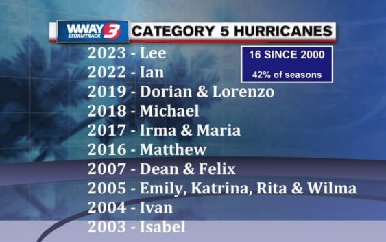
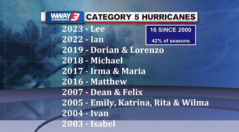
Lee joins a small list of Category 5 hurricanes since 2000.
Dangerous surf and rip currents will spread across the northern Caribbean on Friday and begin affecting the US on Sunday, the center said.
There is increasing confidence that the center of Lee will pass to the north of the Leeward Islands, the Virgin Islands and Puerto Rico this weekend and into early next week. Tropical storm conditions, life-threatening surf and rip currents could occur on some of these islands over the weekend.
Computer model trends for Lee have shown the hurricane taking a turn to the north early next week. But exactly when that turn occurs and how far west Lee will manage to track by then will play a huge role in how close it gets to the US.
Right now, no direct impacts are expected to the Cape Fear. But we will see an increase in swell and rip current risk next week.