- Southport hosts annual Hurricane Expo ahead of the 2024 season
- How to protect your car before a hailstorm
- ‘We lost everything’: East Texas residents confront their future after flooding
- Here's how to get your flooding debris picked up by the City of Houston
- Mosquito activity on the rise due to rainfall, flooding across Texas
Tropical Storm Ophelia forms off Carolina coast
From Charleston to Virginia, storm warnings have been issued with the likely development of a tropical system offshore.
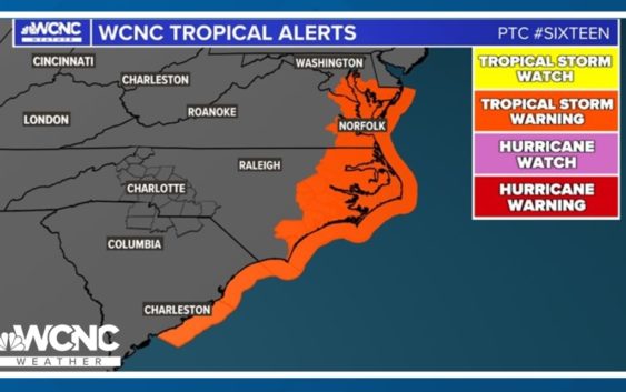
CHARLOTTE, N.C. — A low pressure system is becoming more organized this Friday and the National Weather Service has issued tropical storm warnings for the North Carolina and South Carolina coastline. The State Emergency Response team has moved to an ‘Enhanced Watch’ starting Friday and through Saturday as PTC #16 rolls into North Carolina.
What is PTC #16?
The National Hurricane Service has issued a ‘Potential Tropical Cyclone’ track. This is one of the National Weather Service’s (NWS) advisory products that describes “a disturbance that is not yet a tropical cyclone, BUT which poses the threat of bringing tropical storm or hurricane conditions to land areas within 48 hours.” This is a relatively new advisory, first implemented back in 2017.
Sixteen is expected to become a named storm as early as tomorrow night or Saturday morning as it approaches the North Carolina coast. Regardless of whether it develops as a tropical or subtropical system, the impacts remain the same. Dangerous beach conditions, erosion, large swells, and elevated rip currents are expected along the eastern seaboard.
If this becomes a Subtropical or Tropical Storm, it will be named Ophelia. This would be the 15th named storm of the season but the 16th storm. Click the video below to find out how our first storm of the season was actually unnamed.
The Threats
Storm surge watches and warnings are also in place for life-threatening sea level rise along the east coast. 3-5 feet of surge is possible for parts of coastal North Carolina and Virginia. 1 – 3 feet is possible for the South Carolina coast and through Maryland, Delaware and New Jersey.
Between 2 – 4 inches of rain are possible, too, with isolated totals up to 6 inches. Wind gusts will peak between 45 – 55 mph. Gusts could peak to as high as 60 to 70 mph.
Some of the heavy rain and wind could stretch further inland into locations such as Raleigh, Greensboro, and Fayetteville. Charlotte could be the western edge of forecast impacts, with communities east of Charlotte more likely to see any impacts. Even then, impacts in the greater Charlotte area are expected to be limited to 1 inch of rain and wind gusts up to 30 mph.
WCNC Charlotte’s Weather IQ YouTube channel gives detailed explainers from the WCNC Charlotte meteorologists to help you learn and understand weather, climate and science. Watch previous stories where you can raise your Weather IQ in the YouTube playlist below and subscribe to get updated when new videos are uploaded.