- Southport hosts annual Hurricane Expo ahead of the 2024 season
- How to protect your car before a hailstorm
- ‘We lost everything’: East Texas residents confront their future after flooding
- Here's how to get your flooding debris picked up by the City of Houston
- Mosquito activity on the rise due to rainfall, flooding across Texas
'This is bad news': Brad Panovich tracking severe weather threat next week
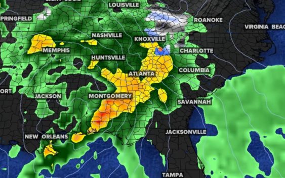
While the first wave could produce some wintry weather, the bigger story is a possible severe weather outbreak in the Carolinas next week, Brad Panovich says.
CHARLOTTE, N.C. — The new year is getting off to an exciting weather start thanks to an active storm track that could bring a wintry mix and severe weather to the Carolinas over the next week or so, according to Chief Meteorologist Brad Panovich.
For the winter lovers out there, we get it. Charlotte just recorded its first calendar year without even a trace of snow. That record dates back all the way to 1878. So if you love snow and wintry weather, you’re probably getting antsy. But while there’s an active storm path, Panovich says there’s still a question mark about it being cold enough for wintry precipitation in Charlotte.
“We’re starting to see a little bit of that pattern change that we’ve been hinting at since the end of last year,” Panovich said. “You can get the idea, wave after wave of storms moving across the country, a much more active storm track.”
Winter weather more likely in the mountains
Panovich said the first wave is more likely to be confined to the mountains. This would be Friday night into Saturday morning with the chance of up to one-quarter of an inch of ice, sleet or snow. By Saturday, the threat expands across the Piedmont but it’s only about a 10% to 30% chance, so not much.
“I really think this is going to be favored toward ice,” Panovich said. “But that’s the kind of area we’re watching if there’s going to be a chance for wintry weather this weekend.”
Panovich said the Interstate 40 corridor and communities in western North Carolina are at a low risk, and that system will move out quickly. Closer to Charlotte, Panovich thinks ice could be a problem Saturday before it turns to a cold, miserable rain.
“We might see some freezing rain at the start of this, maybe a little bit of snow or sleet,” Panovich said. “Everything’s going to change to ice or rain fairly quickly on Saturday, so this is not going to be a long duration event for ice.”
Another wave could produce severe weather
Another storm system will move toward the Carolinas next week out of the Ohio Valley and Midwest. Panovich says this is setup isn’t typically associated with snow for Charlotte, but rather severe weather.
“That’s something that has my attention as well, because we’re goin to be on the warm side of these warm, southerly winds coming in here with strong low pressure,” Panovich explained.
RELATED: Brad Panovich’s winter snow outlook
Panovich said this system will be one to keep an eye on, especially with the warm, wet pattern taking hold this winter. He explained that the winter time jet stream with warm temperatures at the surface is a recipe for severe weather.
“This is bad news,” Panovich said. “That’s a severe weather setup. Probably burying the lede here, everyone gets excited for snow and the potential of some snow and ice this week, but a week from today I think we’re going to be talking about the potential of maybe a winter severe weather outbreak in the Southeast.”
Panovich said this system could create a squall line that produces severe thunderstorms with the risk of heavy rain, damaging winds and isolated tornadoes.