- WATCH: Video Shows Confirmed Tornado touches down in Columbus County
- Residents begin clean up after storms, apparent tornado roll through NC Tuesday
- NC State researchers find increased fecal contamination in coastal waters due to sunny day flooding
- Flooding lingers in Liberty County neighborhoods near Trinity River with more rainfall expected
- North Carolina behind on hurricane preparedness, study shows
Weather Aware: Strong winds, flooding and tornadoes possible Tuesday
Tuesday will be the first Weather Aware Day of 2024. There is a chance for strong wind gusts, downed trees, power outages, flooding and even tornadoes.
CHARLOTTE, N.C. — Tuesday is a day to be Weather Aware. There is a chance for strong to severe thunderstorms, wind gusts up to 50 mph, flooding rains ranging from 1-4″+ across the area and even tornadoes. This is a prime set up for downed trees and power outages. The worst of the weather arrives around noon and all severe threats will close by the evening (per the most recent timing). Let’s go through the threats and timing of this event.
Winds:
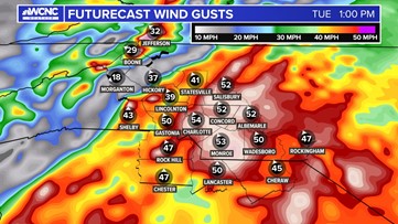
There is a Wind Advisory starting at 10 a.m. through 10 p.m. on Tuesday, January 9, 2024. Winds will be driving out of the South at 20-30 mph through most of the day with peaks to 50 mph during the afternoon. These gusts will be the strongest along a line of strong storms that will be capable of downing trees and causing power outages. Soil is already saturated and this will allow for shallow rooted trees to fall easier than a dry soil where the roots are locked.
Avery County is the only one under a High Wind Warning Meaning wind gusts could reach 65+ mph.

Flooding:
Since December 9, 2023, Charlotte has had over 7 inches of rain. This has helped with the drought but flooding will happen quicker than it did a couple of weeks ago. Rain begins in the morning and will be heavy at times. The heaviest rain will come with a thunderstorm threat in the early to mid afternoon. Right now the best case scenario is 1-2″ of rain but some models are suggesting 3-5″ of rain to be possible with this system. This means quick rising water and a flash flood threat on top of everything else.
Severe Storms and Tornado Threat:
Severe storms will be along a line called a Q.L.C.S. (Quasi-Linear Convective System). Lines like these are prone to the leading edge to bring a swath of the strongest winds of the day and even spin-up tornadoes in the notches.
It is because of this and an ample amount of wind shear that there is an elevated threat for wind damage and tornadoes. The worst of the weather will be east and south east of Charlotte, as the later timing brings more favorable and unstable conditions.
Areas in the red above depict a 30% risk of damaging winds and the hashed marks represent a significant threat which means the possibility of widespread damage. The 10% tornado threat is high with also a significant designation, meaning there could be multiple tornadoes southeast of Charlotte. A tornado watch is likely for your Tuesday.
Timing:
Rain will start in the morning. Some wintry mix in the Mountains initially. Rain should become widespread through the morning commute. There will be less rain in our eastern and southeastern counties to start but this will keep the instability higher for these zones. By the end of the morning, winds are now gusting up to 35-50 mph across the area, and the worst of the weather will arrive into the afternoon. Notice how the line below progresses.
Final Notes:
The ingredients are all lining up for multiple threats throughout the day. Gusty winds will be with us all day, widespread rain causing gradual flooding. Downed trees could lead to multiple power outages and a line of severe thunderstorms is where the worst of the weather will move through. On top of that, dangerous lightning will add one more threat. This is a day to stay weather aware and try to avoid travel (especially late morning and early afternoon around the Charlotte area). Stay safe and we will keep you in the know.