- Severe weather leads to fallen trees, car crashes and flooding around the Triangle
- New video shows vehicles being swept away in historic, deadly flash floods in SA on June 12
- $40 million to go to underserved SC counties for Hurricane Helene recovery. Here's what you need to know.
- Family honors Air Force veteran Derwin Anderson Jr. after he died in June flash floods
- City of Wilmington addresses flooding on New Centre Drive
Live updates: Flood watch & wind advisory in effect for Triangle
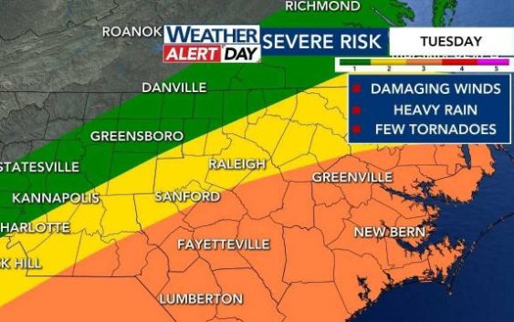
Tuesday is a WRAL Weather Alert Day due to the threat of heavy rainfall, damaging winds, flooding and isolated tornadoes.
Governor Roy Cooper declared a state of emergency for North Carolina due to the possible dangers of Tuesday’s storms.
The Triangle will be under a Level 2 risk for severe weather, and multiple counties southeast of Raleigh, including Cumberland and Harnett, are under a Level 3 risk for severe weather due to a line of storms moving in from the west.
WRAL Weather Alert Day | School closings and delays | Track rain with the DualDoppler5000 | All weather alerts

Live updates
11:24 a.m.: City of Fayetteville asks residents to prepare for the storm by taking the following steps:
- Clear storm drains and remove any debris that could potentially block street storm drains.
- Securely store solid waste and recycling rollout carts away from the road.
11:20 a.m.: Strong winds but little to no rain in Raleigh.
10:40 a.m.: Light showers continue in Raleigh. We’re seeing heavier rainfall in Rocky Mount up to Roanoke Rapids and to the west in Roxboro and Durham.
10 a.m.: Wind advisory now in effect for several central North Carolina counties, including the Triangle, from 10 a.m. until 10 p.m. Tuesday.

9:20 a.m.: Quiet in Raleigh. Some showers in Durham along I-85.
9 a.m.: Flood watch now in effect for the Triangle and western counties.

8:48 a.m.: Durham Tech says it will be closing its campuses Tuesday at noon.
8:30 a.m.: Rain continues to fall across the Triangle.