- Southport hosts annual Hurricane Expo ahead of the 2024 season
- How to protect your car before a hailstorm
- ‘We lost everything’: East Texas residents confront their future after flooding
- Here's how to get your flooding debris picked up by the City of Houston
- Mosquito activity on the rise due to rainfall, flooding across Texas
Weather Aware: Deadly severe storms cause flooding, widespread power outages
Chief Meteorologist Brad Panovich said people should treat all severe thunderstorm warnings as if they were tornado warnings, and seek shelter.
CHARLOTTE, N.C. — Tuesday is a day to be Weather Aware.
A severe thunderstorm warning is in effect for Anson and Richmond counties in North Carolina, as well as Lancaster and Chesterfield counties in South Carolina, until 4:45 p.m. Chief Meteorologist Brad Panovich said people should treat all severe thunderstorm warnings as if they were tornado warnings, and seek shelter. Tornado warnings were in effect for parts of Mecklenburg, Cabarrus and Union counties Tuesday, but they have since expired.
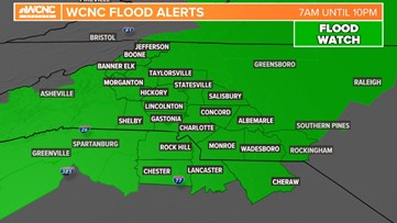
A flash flood warning is in effect for Polk and Rutherford counties until 7:15 p.m. and a flood warning through 1 a.m. for Cleveland County.
These conditions are a prime set up for downed trees and power outages, and outages have already been reported across the region.
One person has died and two others are in critical condition after severe weather hit Catawba County on Tuesday. According to Catawba County Communications, the National Weather Service was in the area to evaluate exactly what type of severe weather hit the area.
PHOTOS: Storm damage in the Carolinas
PHOTOS: Storm damage across the Charlotte area – Jan. 9, 2024
DAMAGE IN THE CAROLIINAS: See the latest damage reports here
North Carolina Gov. Roy Cooper signed an executive order to declare a State of Emergency ahead of Tuesday’s severe weather threat.
Winds
There is a wind advisory that started at 10 a.m. and lasts through 10 p.m. Winds will be driving out of the south at 20 mph to 30 mph throughout most of the day with peaks up to and over 50 mph into the afternoon. These gusts will be the strongest along a line of strong storms capable of downing trees and causing power outages. Soil is already saturated, and this will allow for shallow rooted trees to fall easier than a dry soil where the roots are locked.
Earlier in the day, wind gusts up to 46 mph were reported at Bank of America Stadium.
Winds could be as high as 60 mph in the mountains, since the higher up, the less friction there is preventing winds — that’s led to a high wind warning. Winds peaked in the Charlotte area Tuesday afternoon.
RELATED: Weather IQ: What causes wind?
For the latest weather alerts, download the WCNC Charlotte mobile app and enable push notifications.
Flooding
Since Dec. 9, Charlotte has had more than 7 inches of rain.
This has helped with the drought but flooding will happen quicker than it did a couple of weeks ago. Rain began Tuesday morning, but the heaviest rain fell mid-afternoon.

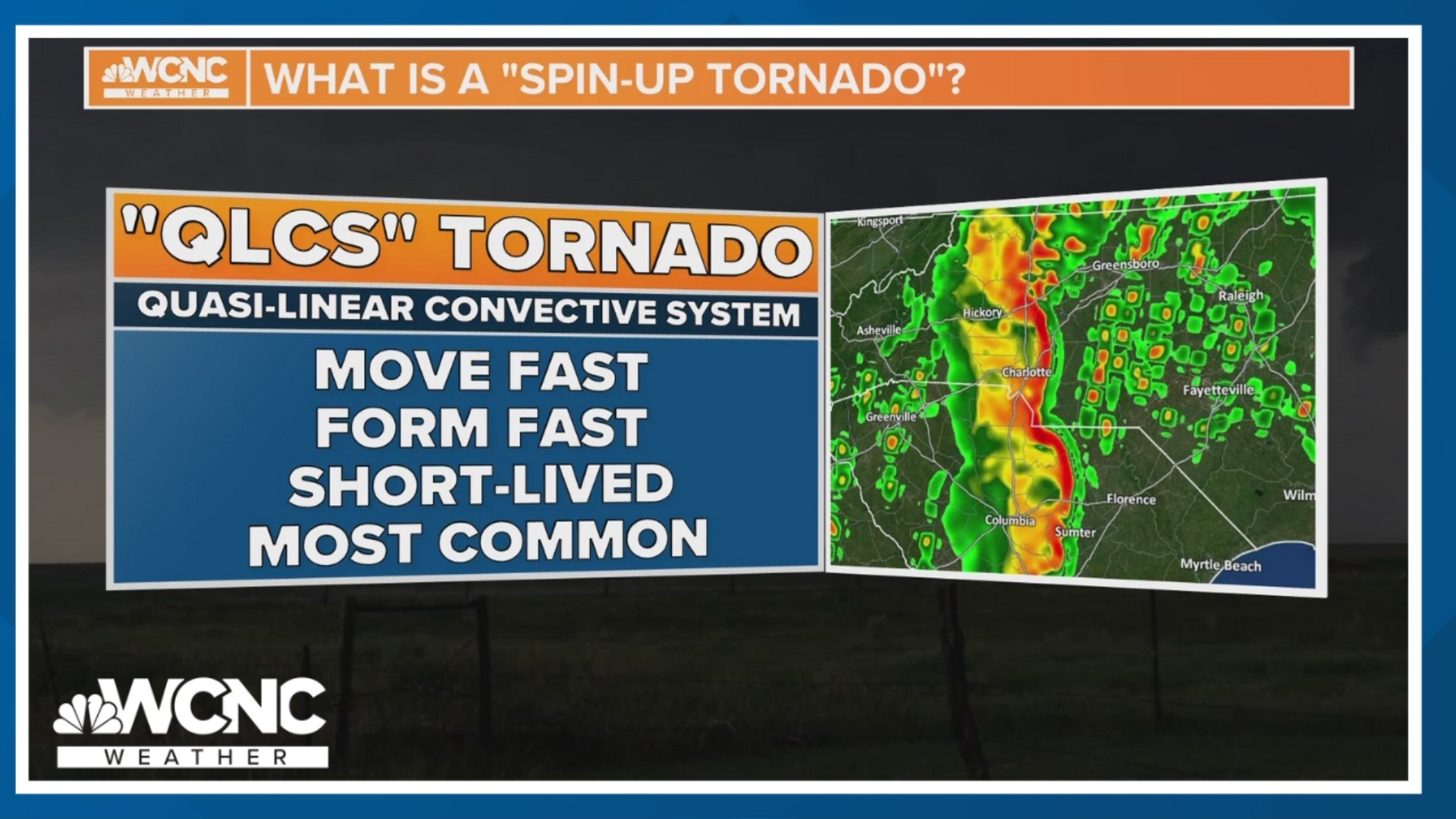
Severe storms and tornado threat
Severe storms followed along a line called a Q.L.C.S. (Quasi-Linear Convective System). Lines like these are prone to the leading edge to bring a swath of the strongest winds of the day and even spin-up tornadoes in the notches.
More Videos
It is because of this and an ample amount of wind shear that there was an elevated threat for wind damage and tornadoes.
The worst of the weather ended up be east and south east of Charlotte.
Final notes
The ingredients were there for multiple threats throughout the day. Gusty winds will continue to be with us late into the night, with widespread rain causing gradual flooding. On top of that, dangerous lightning added one more threat. This is a day to stay Weather Aware and try to avoid the roads.