- EF-1 tornadoes ripped through Cypress, Waller County areas with winds at more than 100 mph, NWS reports
- Houston-area storm damage updates: Clean up continues after NWS says two EF-1 tornadoes and powerful derecho ripped through SE Texas
- Low risk of damaging winds, hail from Saturday storms
- EF 1 tornadoes ripped through Cypress, Waller County areas at more than 100 mph, NWS reports
- Caddo Mounds State Historic Site to celebrate new visitor center, traditional grass house after 2019 tornado
No evidence of a tornado in Rock Hill, investigation determines
The severe thunderstorm Saturday caused extensive damage from large hail and strong winds.
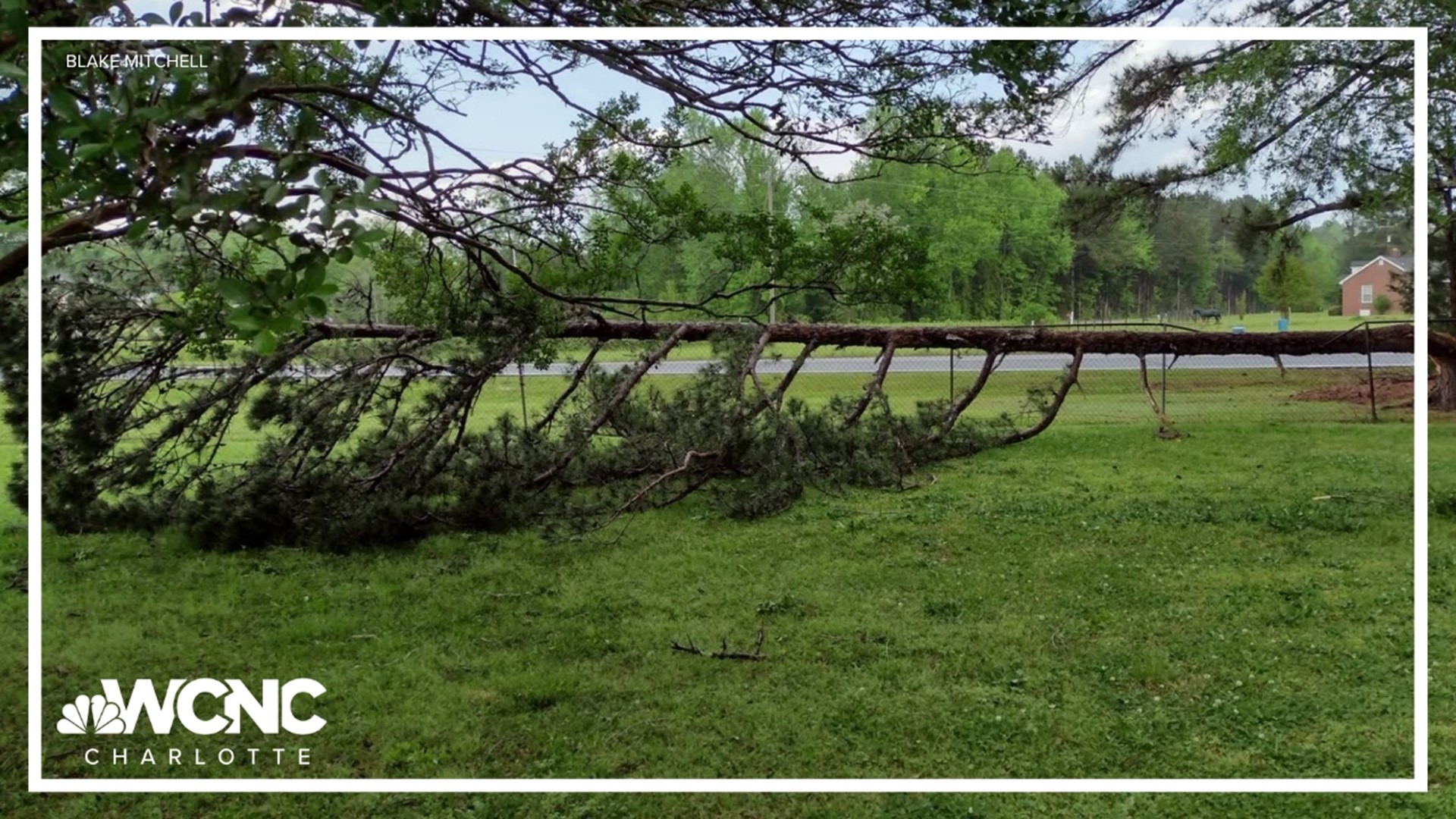
ROCK HILL, S.C. — Extensive storm damage left behind in Rock Hill, South Carolina from a thunderstorm Saturday was caused by excessive winds and not a tornado, the National Weather Service determined Monday.
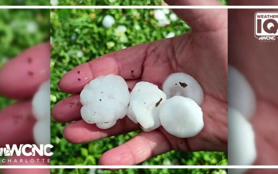
The supercell thunderstorm produced winds up to 90 mph as it moved through York County late Saturday afternoon. These winds, the equivalent of a Category 1 hurricane, toppled trees and damaged homes. The storm also produced hail stones at least two inches big.
Steve Wilkinson, the meteorologist in charge of the local National Weather Service office in Greenville-Spartanburg, said they are still working to determine if the storm could have produced hail up to four inches, as some rumors have suggested.
After powerful storms rolled through Rock Hill this weekend, people are still cleaning up the mess left behind by the severe weather.
Officials with the National Weather Service and York County Emergency Management office visited some of the locations hardest hit by storm damage. Their goal is to determine the strength of the storm that shattered windows and brought down trees and powerlines. They are also looking to answer the question of whether or not the storm produced a tornado.
Officials are expected to discuss their findings during a 2:30 p.m. news conference in Rock Hill.
Days later, Rock Hill Schools kept students home Monday for a day of virtual learning citing impassable roads and some school buildings without power.
The thunderstorm Saturday afternoon developed into what meteorologists call a supercell thunderstorm. The storm produced winds over 60 mph and hail two inches wide. Damage from the storm included smashed car windshields, roof damage, and thousands of people without electricity.
More Videos
WCNC Charlotte Meteorologist Chris Mulcahy explained the storm was able to produce such large hail stones because of its powerful updraft. These updraft winds carried the hail to 30,000 feet in the atmosphere. At this elevation, the air temperature is -40 degrees. This allowed the stones to grow to a size slightly larger than a golf ball.
A hailstorm caused even more damage, pelting houses and cars with golf ball-sized hail. The hail shattered glass and left visible signs of damage.
More Videos
For the latest weather alerts, download the WCNC Charlotte mobile app and enable push notifications.
WCNC Charlotte spoke to some students at Winthrop University, who described what they heard and saw. One student said he heard people screaming at the time, and another said it sounded like someone threw a bucket of rocks at the window.
The National Weather Service Saturday issued a Severe Thunderstorm Warning for the thunderstorm. This type of severe weather warning means a storm is capable of damaging wind and hail.
With such extensive damage left behind, many speculated the storm could have formed a tornado. While winds of this speed can be just as damaging as a tornado, National Weather Service investigators visited the site Monday, in part, to see if there was any evidence the storm could have produced a tornado.
Contact Richard DeVayne at rdevayne@wcnc.com and follow him on Facebook, X and Instagram.
WCNC Charlotte To Go is a daily news and weather podcast you can listen to so you can start your day with the team at WCNC Charlotte.
SUBSCRIBE: Apple Podcasts || Spotify || Pandora || TuneIn || Google Podcasts || iHeart
All of WCNC Charlotte’s podcasts are free and available for both streaming and download. You can listen now on Android, iPhone, Amazon, and other internet-connected devices. Join us from North Carolina, South Carolina, or on the go anywhere.