- Hurricane survival kit: How to keep your family safe when a hurricane hits
- Houston-area storm damage: Update on status of schools, power outages and resources for storm victims
- EF-1 tornadoes ripped through Cypress, Waller County areas with winds at more than 100 mph, NWS reports
- Houston-area storm damage updates: Clean up continues after NWS says two EF-1 tornadoes and powerful derecho ripped through SE Texas
- Low risk of damaging winds, hail from Saturday storms
Panovich: 'Don't be surprised' if Charlotte sees severe weather on Thursday
A line of strong thunderstorms is expected to hit the Charlotte area early Thursday. Brad Panovich breaks down the timing and impacts.
CHARLOTTE, N.C. — There is a risk for severe weather, including strong thunderstorms, across the Charlotte area over the next few days, including a line of storms that could hit early Thursday morning, Chief Meteorologist Brad Panovich said.
Panovich declared Wednesday and Thursday as Weather Aware days in the Charlotte area. This means there is a chance for severe weather that could impact people’s safety and their property. These storms are also expected to impact the Wells Fargo Championship at Quail Hollow.
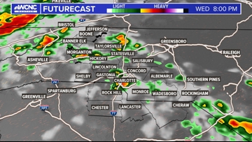
Severe weather threat
The Carolinas could see isolated strong thunderstorms at any point on Wednesday, but the biggest threat will be late Wednesday night into Thursday morning. Panovich said this wave of storms could produce heavy rain, damaging winds and isolated tornadoes as it pushes east across the Charlotte region.
Panovich cautioned any storms that develop on Wednesday will have the potential to be severe due to the instability in the atmosphere.
“If we can get a storm to develop on Wednesday, it will certainly be severe because of the setup,” he said. “I’m not writing off the fact that there could be some strong storms Wednesday evening, but what is becoming increasingly likely is that our biggest risk of storms is going to be early on Thursday morning.”

A second wave of storms is likely later in the morning on Thursday. Panovich expects these storms to impact the Wells Fargo Championship at Quail Hollow Club. The good news is things should clear out by the middle of the day and we’re looking at much nicer weather through the weekend.
“It looks like those storms will have used up so much energy in the atmosphere there may not be time for the atmosphere to reload or get re-intensified because at the same time, there’s a cold front sweeping in,” Panovich said. “So it’s a race to see if things get unstable again before the front or is there not enough time and the front gets in and clears everything out.”
Panovich said it’s looking more likely that the front will arrive first, leading to a sunny, pleasant afternoon in the Carolinas.
Storm timing
Panovich said from 11 p.m. Wednesday through 11 a.m. Thursday will be the prime window for strong thunderstorms in Charlotte. He said the atmosphere will be primed for severe weather by Wednesday afternoon and evening.
“As we get into the afternoon, evening hours, there’s definitely some potential there,” Panovich said. “At 8 p.m. on Wednesday, there are some ingredients there for some isolated tornadoes, if we can get storms to develop.”
The threat will diminish by late Thursday morning but not until the first wave of storms moves through. Panovich said these storms could have a big impact on Thursday’s morning commute. The worst of it is expected to move out around 9 a.m.
“There’s going to be some strong storms early Thursday morning, so don’t be surprised,” Panovich said. “I really think this is going to be the case. Early Thursday morning is going to be our window for the worst weather.”
WCNC Charlotte To Go is a daily news and weather podcast you can listen to so you can start your day with the team at WCNC Charlotte.
SUBSCRIBE: Apple Podcasts || Spotify || Pandora || TuneIn || Google Podcasts || iHeart
All of WCNC Charlotte’s podcasts are free and available for both streaming and download. You can listen now on Android, iPhone, Amazon, and other internet-connected devices. Join us from North Carolina, South Carolina, or on the go anywhere.