- They couldn’t save their daughters’ lives in the July 4 floods. Now they’re dealing with the grief and the guilt.
- Austin could see heavy rains, possible flooding over the next few days
- Families of campers, counselors who died in Texas Hill County floods sue Camp Mystic
- Small plane bound for Jamaica with hurricane relief supplies crashes in Florida neighborhood
- Ask the Meteorologist: Did a tornado hit Johnston County Saturday night?
NASA video shows Hurricane Milton from space as it nears Florida
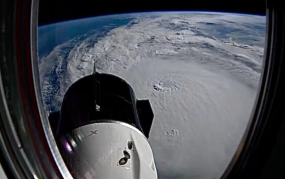
Hurricane Milton’s massive size was on display as the International Space Station flew over the monstrous storm.
WASHINGTON — Hurricane Milton remains a ferocious storm that could land a once-in-a-century direct hit on Tampa and St. Petersburg, engulfing the populous region with towering storm surges and turning debris from Helene’s devastation two weeks ago into projectiles.
NASA released footage of the view of Milton from the International Space Station on Tuesday as it approached as a Category 4 storm.
The National Hurricane Center predicted Milton, which fluctuated between categories 4 and 5 as it approached, would be a major and extremely dangerous storm when its center makes landfall late Wednesday or early Thursday.
Milton looms in the Gulf less than two weeks after a catastrophic Hurricane Helene swamped the coastline and killed more than 230 people in several Southeast states.
NASA astronaut Matthew Dominick shared a new time-lapse Wednesday morning as the space station flew over the monstrous storm. He noted it looked bigger than yesterday, but less symmetrical.
Hurricane Milton churned Wednesday toward a potentially catastrophic collision along the west coast of Florida, where some residents insisted they would stay after millions were ordered to evacuate and officials warned that stragglers would face grim odds of surviving.
The Tampa Bay area, home to more than 3.3 million people, faced the possibility of widespread destruction after avoiding direct hits from major hurricanes for more than a century.
Milton was centered about 230 miles southwest of Tampa on Wednesday morning, with maximum sustained winds of 155 mph, just 2 mph shy of Category 5 status, the hurricane center reported. It was moving northeast at 16 mph and was expected to continue moving in that direction with an increase in its forward speed through Wednesday night.