- They couldn’t save their daughters’ lives in the July 4 floods. Now they’re dealing with the grief and the guilt.
- Austin could see heavy rains, possible flooding over the next few days
- Families of campers, counselors who died in Texas Hill County floods sue Camp Mystic
- Small plane bound for Jamaica with hurricane relief supplies crashes in Florida neighborhood
- Ask the Meteorologist: Did a tornado hit Johnston County Saturday night?
Austin removed from Tornado Watch; threat continues east of I-35
The Tornado Watch will expire in eastern portions of the KVUE area by 4 p.m. Tuesday.
AUSTIN, Texas — Tuesday has been an active weather day across Central Texas, bringing hail, strong winds, flooding and several tornado warnings, including a confirmed tornado in Milam County.
The severe weather threat has ended for the Austin metro and the Interstate 35 corridor, but it continues through 4 p.m. for Caldwell, Bastrop, Lee and Fayette counties. Conditions remain unstable along the Interstate 10 corridor, where the atmosphere is still quite favorable for severe storms.
If you’re in the affected areas, please stay weather-aware and ensure you have a reliable way to receive alerts. After about 4 p.m., the severe threat is expected to diminish for the entire KVUE viewing area.

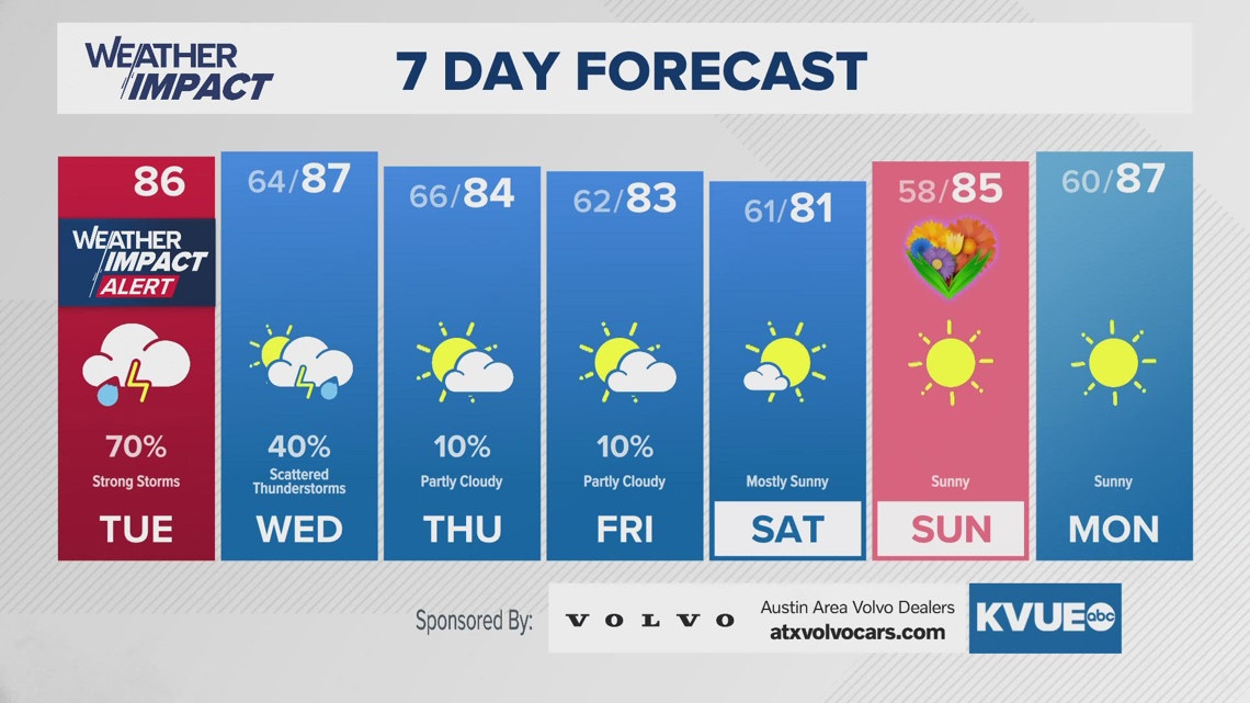
Overnight, conditions should remain quiet, with increasing cloud cover and lows dipping into the mid- to upper 60s. Wednesday brings one final chance for scattered showers and storms. While coverage won’t be as widespread as Tuesday, some storms could still become strong to severe, with wind and hail as the main concerns.
The Storm Prediction Center outlines another “marginal” – Level 1 of 5 – severe weather threat for the majority of the KVUE area.
Beyond Wednesday, the forecast turns much quieter for the remainder of the workweek and into Mother’s Day weekend. Expect mainly dry conditions with highs in the low to mid-80s. Sunday looks pleasant for Mother’s Day, featuring sunshine and continued pleasant temperatures.
The KVUE Weather Team will keep a close eye on this evolving forecast.
In the meantime, check out the extended outlook below: